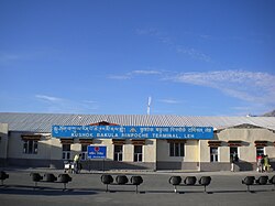
Kushok Bakula Rimpochhe Airport
| Kushok Bakula Rimpochee Airport | |||||||||||
|---|---|---|---|---|---|---|---|---|---|---|---|
 |
|||||||||||
| Summary | |||||||||||
| Airport type | Public | ||||||||||
| Operator | Airport Authority of India | ||||||||||
| Serves | Leh | ||||||||||
| Location | Leh, Jammu and Kashmir, India | ||||||||||
| Elevation AMSL | 3,256 m / 10,682 ft | ||||||||||
| Coordinates | 34°08′09″N 077°32′47″E / 34.13583°N 77.54639°ECoordinates: 34°08′09″N 077°32′47″E / 34.13583°N 77.54639°E | ||||||||||
| Map | |||||||||||
| Runways | |||||||||||
|
|||||||||||
| Statistics (April 2016 - March 2017) | |||||||||||
|
|||||||||||
|
Source: AAI
|
|||||||||||
| Passenger movements | 563,800 ( |
|---|---|
| Aircraft movements | 4,904 ( |
| Cargo tonnage | 1,665 ( |
Kushok Bakula Rimpochee Airport (IATA: IXL, ICAO: VILH) is an airport in Leh, Jammu and Kashmir, India. It is one of the highest commercial airports in the world at 3,256 m (10,682 ft) above mean sea level. The airport is named after 19th Kushok Bakula Rinpoche, an Indian statesman and monk.
Due to the presence of mountain winds in the afternoon, all flights take off and land in the morning. The approach is challenging as it is unidirectional and has high terrain towards the eastern end of the airport. Airport security is tight with Indian Army patrols and no hand baggage is allowed on flights. Due to its location in between the Mountain ranges of Himalayas the approach to Leh Airport has been named and nominated as one of the world's most scenic approaches which makes this airport a scenic airport to land into and take off from.
In February 2016, Indian Air Force handed the airport to Airport Authority of India. AAI will expand it for civilian purposes.
...
Wikipedia


