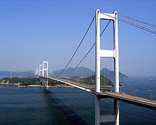
Kurushima-Kaikyō Bridge
|
Kurushima-kaikyō Bridge 来島海峡大橋 |
|
|---|---|
 |
|
| Coordinates | 34°07′14″N 132°59′51″E / 34.12056°N 132.99750°ECoordinates: 34°07′14″N 132°59′51″E / 34.12056°N 132.99750°E |
| Carries | 4 lanes of roadway moped lane bicycle/pedestrian lane |
| Crosses | Seto Inland Sea |
| Locale | Imabari, Ehime, Japan |
| Maintained by | Honshū-Shikoku Bridge Project |
| Characteristics | |
| Design | Suspension bridge |
| Total length | 4,015 metres (13,173 ft) |
| Width | 27 metres (89 ft) |
| History | |
| Construction begin | May 15, 1988 |
| Opened | May 1, 1999 |
The Kurushima-Kaikyō Bridge (来島海峡大橋 Kurushima Kaikyō Ō-hashi?), which connects the island of Ōshima to the main part of Shikoku, is the world's longest suspension bridge structure and was completed in 1999. The bridge is part of the Shimanami Kaidō, an expressway that spans a series of islands and connects Hiroshima Prefecture in Honshū to Ehime Prefecture in Shikoku. The bridge and the expressway were both conceived by the Honshū-Shikoku Bridge Project.
The Kurushima-Kaikyō Bridge consists of three successive suspension bridges with six towers and four anchorages. There is a shared anchorage that joins each suspension bridge to the next. Its construction is similar to the western portion of San Francisco–Oakland Bay Bridge which is two successive suspension bridges with four towers and one shared anchorage. The bridge's total length of 4,015 metres (13,173 ft), is just a little longer than the total length of the two tower Akashi-Kaikyō Bridge, which is 3,911 metres (12,831 ft).
...
Wikipedia

