Shikoku
| Native name: 四国 | |
|---|---|

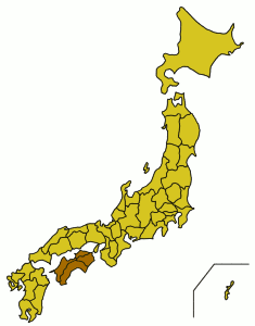
The island of Shikoku, Japan
|
|
| Geography | |
| Location | East Asia |
| Archipelago | Japanese Archipelago |
| Area | 18,800 km2 (7,300 sq mi) |
| Area rank | 50th |
| Length | 225 km (139.8 mi) |
| Width | 50–150 km (31–93 mi) |
| Highest elevation | 1,982 m (6,503 ft) |
| Highest point | Mount Ishizuchi |
| Administration | |
|
Japan
|
|
| Prefectures |
|
| Largest settlement | Matsuyama (pop. 514,865) |
| Demographics | |
| Population | 3,845,534 (2015) |
| Pop. density | 204.55 /km2 (529.78 /sq mi) |
| Ethnic groups | Japanese |
Shikoku (四国?, "four provinces") is the smallest (225 km or 139.8 mi long and between 50 and 150 km or 31.1 and 93.2 mi wide) and least populous (4,141,955 as of 2005[update]) of the four main islands of Japan, located south of Honshu and east of the island of Kyushu. Its ancient names include Iyo-no-futana-shima (伊予之二名島), Iyo-shima (伊予島), and Futana-shima (二名島). The current name refers to the four former provinces that made up the island: Awa, Tosa, Sanuki, and Iyo.
Shikoku island, comprising Shikoku and its surrounding islets, covers about 18,800 square kilometres (7,259 sq mi) and consists of four prefectures: Ehime, Kagawa, Kōchi, and Tokushima. Across the Inland Sea lie Wakayama, Osaka, Hyōgo, Okayama, Hiroshima, and Yamaguchi Prefectures on Honshu. To the west lie Ōita and Miyazaki Prefectures on Kyushu.
...
Wikipedia
