Kurozwęki
| Kurozwęki | ||
|---|---|---|
| Village | ||

|
||
|
||
| Coordinates: 50°35′24″N 21°06′08″E / 50.59000°N 21.10222°E | ||
| Country |
|
|
| Voivodeship | Świętokrzyskie | |
| County | Staszów County | |
| Gmina | Gmina Staszów | |
| Sołectwo | Kurozwęki | |
| Elevation | 225.6 m (740.2 ft) | |
| Population (31 December 2009 at Census) | ||
| • Total | 767 | |
| Time zone | CET (UTC+1) | |
| • Summer (DST) | CEST (UTC+2) | |
| Postal code | 28–200 | |
| Area code(s) | +48 15 | |
| Car plates | TSZ | |
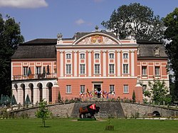
Kurozwęki[kurɔˈzvɛnki] is a village in the district of Gmina Staszów, within Staszów County, Świętokrzyskie Voivodeship, in south-central Poland. It lies on the Czarna Staszowska river, in the historic province of Lesser Poland, approximately 6 kilometres (4 mi) north-west of Staszów and 48 km (30 mi) south-east of the regional capital Kielce.
The village's history dates back to the 13th century. It had city rights from before 1400 to 1870. It has several tourist attractions, including a 14th-century palace, open for visitors, with a bison farm nearby, and a 15th-century church. The village has a population of ![]() 767.
767.
Some time in the mid 14th century, local knight Dobiesław of Kurozwęki built here a castle, which became the seat of the Kurozwęcki noble family (see szlachta). At first the castle was of defensive character, but in the course of the time it was remodeled several times. It is not known when exactly Kurozwęki received town charter, most probably it happened before the year 1400. The town belonged to several families – the Kurozwęcki, the Lanckoroński, the Potocki and the Popiel. In the 17th century, when Kurozwęki belonged to Lesser Poland's Sandomierz Voivodeship, it was one of the centers of Protestant Reformation, especially Calvinism. In 1870, the government of Russian-controlled Congress Poland (see Partitions of Poland) deprived it of the town charter.
...
Wikipedia


