Kunashiri Island
| Disputed island Native name: Kunashir Island (Ainu) Other names: Russian: Кунаши́р; Japanese: 国後島 |
|
|---|---|

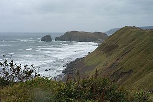
Kunashir Island coastline: photo taken by Russian President Dmitry Medvedev in November 2010.
|
|
| Geography | |
| Location | Sea of Okhotsk |
| Coordinates | 44°07′N 145°51′E / 44.117°N 145.850°E |
| Archipelago | Kuril Islands |
| Area | 1,490 square kilometres (370,000 acres) |
| Length | 123 kilometres (76 mi) |
| Width | from 4 kilometres (2.5 mi) to 30 kilometres (19 mi) |
| Highest point |
|
| Administered by | |
| Russia | |
| Oblast | Sakhalin |
| Largest city | Yuzhno-Kurilsk |
| Claimed by | |
| Japan | |
| Prefecture | Hokkaido |
| Capital city | Tokyo |
| Demographics | |
| Population | approx. 7800 (as of 2002) |
Kunashir Island (Russian: Кунаши́р; Japanese: 国後島, Kunashiri-tō; Ainu: クナシㇼ or クナシㇽ, Kunasir), possibly meaning Black Island or Grass Island in Ainu, is the southernmost island of the Kuril Islands, an archipelago currently under Russian control, among which four of (among them Kunashiri Island) are claimed by Japan (see Kuril Islands dispute).
It lies between the straits of Kunashir Island, Catherine, Izmena, and South Kuril. Kunashir Island is visible from the nearby Japanese island of Hokkaido, from which it is separated by the Nemuro Strait.
Kunashir Island is formed by four volcanoes which were separate islands but have since joined together by low-lying areas with lakes and hot springs. All these volcanoes are still active: Tyatya (1,819 m), Smirnov, Mendeleev (Rausu-yama), and Golovnin (Tomari-yama).
The island is made up of volcanic and crystalline rocks. The climate is humid continental with very heavy precipitation especially in the autumn and a strong seasonal lag with maximum temperatures in August and September. The vegetation mostly consists of spruce, pine, fir, and mixed deciduous forests with lianas and Kuril bamboo underbrush. The mountains are covered with birch and Siberian Dwarf Pine scrub, herbaceous flowers or bare rocks.
...
Wikipedia

