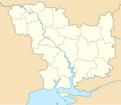
Kryve Ozero
|
Kryve Ozero Криве Озеро |
|
|---|---|
| Urban-type settlement | |
| Coordinates: 47°56′43″N 30°21′10″E / 47.94528°N 30.35278°ECoordinates: 47°56′43″N 30°21′10″E / 47.94528°N 30.35278°E | |
| Country | Ukraine |
| Oblast | Mykolaiv Oblast |
| Raion | Kryve Ozero Raion |
| Population (2015) | |
| • Total | 7,821 |
| Time zone | EET (UTC+2) |
| • Summer (DST) | EEST (UTC+3) |
Kryve Ozero (Ukrainian: Криве Озеро, Russian: Кривое Озеро) is an urban-type settlement in the northwest of Mykolaiv Oblast, Ukraine. It serves as the administrative center of Kryve Ozero Raion. Population: 7,821 (2015 est.)
The settlement is located on the banks of the Kodyma River, a right tributary of the Southern Buh.
Kryve Ozero was founded in 1762.
In the 1920s, Kryve Ozero belonged to Odessa Governorate. In 1923, uyezds in Ukrainian Soviet Socialist Republic were abolished, and the governorates were divided into okruhas. In 1923, Kryve Ozero Raion with the administrative center in Kryve Ozero was established. It belonged to Pervomaisk Okruha. In 1925, the governorates were abolished, and okruhas were directly subordinated to Ukrainian SSR. In 1930, okruhas were abolished, and on 27 February 1932, Odessa Oblast was established, and Kryve Ozero was included into Odessa Oblast. In February 1954, Kryve Ozero Raion was transferred to Mykolaiv Oblast. In 1976, Kryve Ozero was granted urban-type settlement status.
The closest railway station is in Liubashivka 14 kilometres (8.7 mi) to the south. It has connections to Pervomaisk and Kotovsk.
...
Wikipedia

