Krasnokholmsky District
| Krasnokholmsky District Краснохолмский район (Russian) |
|
|---|---|
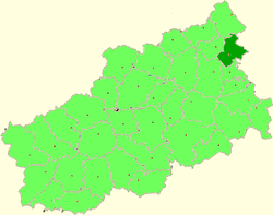
 Location of Krasnokholmsky District in Tver Oblast |
|
| Coordinates: 58°03′58″N 37°07′16″E / 58.06611°N 37.12111°ECoordinates: 58°03′58″N 37°07′16″E / 58.06611°N 37.12111°E | |
|
|
|
| Location | |
| Country | Russia |
| Federal subject | Tver Oblast |
| Administrative structure (as of 2013) | |
| Administrative center | town of Krasny Kholm |
| Administrative divisions: | |
| Urban settlements | 1 |
| Rural settlements | 3 |
| Inhabited localities: | |
| Cities/towns | 1 |
| Rural localities | 206 |
| Municipal structure (as of May 2013) | |
| Municipally incorporated as | Krasnokholmsky Municipal District |
| Municipal divisions: | |
| Urban settlements | 1 |
| Rural settlements | 3 |
| Statistics | |
| Area | 1,495 km2 (577 sq mi) |
| Population (2010 Census) | 11,835 inhabitants |
| • Urban | 47.4% |
| • Rural | 52.6% |
| Density | 7.92/km2 (20.5/sq mi) |
| Time zone | MSK (UTC+03:00) |
| Official website | |
| on | |
Krasnokholmsky District (Russian: Краснохо́лмский райо́н) is an administrative and municipal district (raion), one of the thirty-six in Tver Oblast, Russia. It is located in the northeast of the oblast and borders with Vesyegonsky District in the north, Breytovsky District of Yaroslavl Oblast in the northeast, Nekouzsky District, also of Yaroslavl Oblast, in the southeast, Sonkovsky District in the south, Bezhetsky District in the southwest, and with Molokovsky District in the northwest. The area of the district is 1,495 square kilometers (577 sq mi). Its administrative center is the town of Krasny Kholm. Population: 11,835 (2010 Census);14,736 (2002 Census);18,813 (1989 Census). The population of Krasny Kholm accounts for 47.4% of the district's total population.
The whole of the district belongs to the basin of the Rybinsk Reservoir. The rivers in the west of the district drain into the Mogocha, which joins the Melecha outside of the district to form the Osen, a major right tributary of the Mologa. The source of the Mogocha is located within the district. The rivers in the east of the district drain into the Rybinsk Reservoir and its tributaries, including the Sit. Much of the district's territory is covered by forests.
...
Wikipedia

