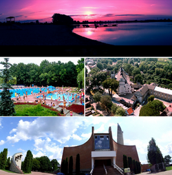
Kraśnik
| Kraśnik | |||
|---|---|---|---|

Kraśnik
|
|||
|
|||
| Coordinates: 50°55′N 22°13′E / 50.917°N 22.217°E | |||
| Country |
|
||
| Voivodeship | Lublin | ||
| County | Kraśnik County | ||
| Gmina | Kraśnik (urban gmina) | ||
| Established | 14th century | ||
| Town rights | 1377 | ||
| Government | |||
| • Mayor | Mirosław Włodarczyk | ||
| Area | |||
| • Total | 25.29 km2 (9.76 sq mi) | ||
| Population (2006) | |||
| • Total | 36,072 | ||
| • Density | 1,400/km2 (3,700/sq mi) | ||
| Time zone | CET (UTC+1) | ||
| • Summer (DST) | CEST (UTC+2) | ||
| Postal code | 23-200, 23-210 | ||
| Area code(s) | +48 81 | ||
| Car plates | LKR | ||
| Website | http://www.krasnik.pl | ||
Coordinates: 50°56′N 22°13′E / 50.933°N 22.217°E
Kraśnik [ˈkraɕɲik] is a town in eastern Poland with 35,602 inhabitants (2012), situated in the Lublin Voivodeship, historic Lesser Poland. It is the seat of Kraśnik County. The town of Kraśnik as we know it today was created in 1975, after the merger of its two districts - Kraśnik Lubelski, and Kraśnik Fabryczny. Kraśnik has a sports club Stal, founded in 1951.
Kraśnik is located in Lesser Poland, among the hills of Lublin Upland, 49 kilometers south-west of Lublin. The town is divided into two major parts, which are a few kilometers apart: Kraśnik Fabryczny and Kraśnik Lubelski (or Kraśnik Stary, Old Kraśnik). The town has the area of 25,28 square kilometers, of which arable land makes 45%, and forests, 17%.
Kraśnik Lubelski is the original part of the town, where all historic buildings are located. It is made of several districts, such as Old Town, Bojanówka, Koszary, Góry, Zarzecze, Kwiatkowice, and Osiedle Kolejowe. Kraśnik Lubelski has old churches and the oldest cemetery of the town, as well as a rail station, a bus station and main administrative offices of the county. It also is a major road junction, where future Expressway S19 (current National Road Nr. 19) meets National Road Nr. 74. Until 2010, the Road 74 went through the center of Kraśnik, but now there is a by-pass.
Kraśnik Fabryczny was founded in the late 1930s, as a settlement for State Ammunition Factory No. 2 (Panstwowe Fabryka Amunicji nr. 2), one of the enterprises built as part of the Central Industrial Region. Previously, in the location of Kraśnik Fabryczny there was the village of Dąbrowa Bór, placed a few kilometers northwest of Kraśnik, in a forest between Kraśnik and Urzędów. The government of the Second Polish Republic planned a new settlement, built from scratch, for 6,000 people around the new Ammunition Factory Nr. 2, FLT-Kraśnik. After the war, the settlement of Dąbrowa Bór was expanded, and in 1954 its name was changed to Kraśnik Fabryczny. In the 1960s, a number of single-family houses was built, later on, several blocks of flats were constructed. On October 1, 1975, Kraśnik Fabryczny merged with Kraśnik Lubelski, and the villages of Budzyń and Piaski, creating the town of Kraśnik. Currently, Kraśnik Fabryczny has some 20,000 inhabitants.
...
Wikipedia


