Komsomolsk-na-Amure
| Komsomolsk-on-Amur (English) Комсомольск-на-Амуре (Russian) |
|
|---|---|
| - City - | |
 View of Komsomolsk-on-Amur |
|
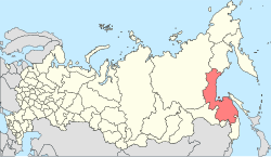
 Location of Khabarovsk Krai in Russia |
|
|
|
|
|
|
|
|
|
|
| Administrative status (as of September 2011) | |
| Country | Russia |
| Federal subject | Khabarovsk Krai |
| Administratively subordinated to | city of krai significance of Komsomolsk-na-Amure |
| Administrative center of | city of krai significance of Komsomolsk-na-Amure,Komsomolsky District |
| Municipal status (as of June 2004) | |
| Urban okrug | Komsomolsk-na-Amure Urban Okrug |
| Administrative center of | Komsomolsk-na-Amure Urban Okrug, Komsomolsky Municipal District |
| Head | Vladimir Mikhalyov |
| Statistics | |
| Area | 325.10 km2 (125.52 sq mi) |
| Population (2010 Census) | 263,906 inhabitants |
| - Rank in 2010 | 70th |
| Density | 812/km2 (2,100/sq mi) |
| Time zone | VLAT (UTC+10:00) |
| Founded | 1932 |
| City status since | 1933 |
| Postal code(s) | 6810xx |
| Dialing code(s) | +7 4217 |
|
|
|
| on | |
Komsomolsk-on-Amur (Russian: Комсомольск-на-Амуре, tr. Komsomolsk-na-Amure; IPA: [kəmsɐˈmolʲsk nɐɐˈmurʲə]) is a city in Khabarovsk Krai, Russia, located on the left bank of the Amur River in the Russian Far East. It is located on the Baikal-Amur Mainline, 356 kilometers (221 mi) northeast of Khabarovsk. Population: 263,906 (2010 Census);281,035 (2002 Census);315,325 (1989 Census).
The city and its suburbs stretch for over 30 kilometers (19 mi) along the left bank of the Amur River. The river at this point is up to 2.5 kilometers (1.6 mi) wide.
The distance to Khabarovsk—the administrative center of the krai—is 356 kilometers (221 mi); to the Pacific Ocean—about 300 kilometers (190 mi). The nearest other major town is Amursk, about 45 kilometers (28 mi) south.
It is about 3,900 miles (6,300 km) east of Moscow, and lies at the eastern end of the BAM Railway.
The future site of Komsomolsk-on-Amur was conquered by Mongols in the 13th century, becoming part of Mongol Empire under the Mongol Yuan Dynasty and later Manchus held until 1858 treaty of Aigun ceded the area to the Russian Empire.
...
Wikipedia


