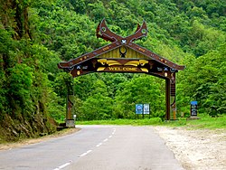
Kohima district
| Kohima district | |
|---|---|
| District | |

Entrance to Kohima district
|
|
 Kohima district's location in Nagaland |
|
| Coordinates: 25°40′N 94°07′E / 25.667°N 94.117°ECoordinates: 25°40′N 94°07′E / 25.667°N 94.117°E | |
| State | Nagaland |
| Country | India |
| Seat | Kohima |
| Elevation | 1,444 m (4,738 ft) |
| Population (2011) | |
| • Total | 2,70,063 |
| Time zone | IST (UTC+05:30) |
| ISO 3166 code | IN-NL-KO |
| Website | http://kohima.nic.in/ |
Kohima district (pron:/ˈkəʊhɪˌmɑː or kəʊˈhiːmə/) is a district of Nagaland state in India. It is the home of the Angami Naga tribe. As of 2011 it is the second most populous district of Nagaland (out of 11), after Dimapur.
According to the 2011 census Kohima district has a population of 270,063, roughly equal to the nation of Barbados. This gives it a ranking of 576th in India (out of a total of 640). Its population growth rate over the decade 2001-2011 was 0%. Kohima has a sex ratio of 927 females for every 1000 males, and a literacy rate of 85.58%.
The main indigenous inhabitants of Kohima district are the Angami Nagas and the Rengma.
In 1980 Kohima district became home to the Puliebadze Wildlife Sanctuary, which has an area of 9.2 km2 (3.6 sq mi). It is a natural habitat for Blyth’s Tragopan.
Kohima is also home to Kohima Komets a soccer club which plays in Nagaland Premier League.
...
Wikipedia
