Nagaland
| Nagaland | ||
|---|---|---|
| State | ||
|
||
 |
||
| Coordinates (Kohima): 25°40′N 94°07′E / 25.67°N 94.12°ECoordinates: 25°40′N 94°07′E / 25.67°N 94.12°E | ||
| Country |
|
|
| Formation | 1 December 1963 | |
| Capital | Kohima | |
| Largest city | Dimapur | |
| Districts | 11 | |
| Government | ||
| • Governor | Padmanabha Acharya | |
| • Chief Minister | Shürhozelie Liezietsu | |
| • Legislature | Unicameral (60 seats) | |
| • Parliamentary constituency |
Rajya Sabha 1 Lok Sabha 1 |
|
| • High Court | Gauhati High Court – Kohima Bench | |
| Area | ||
| • Total | 16,579 km2 (6,401 sq mi) | |
| Area rank | 26th | |
| Population (2011) | ||
| • Total | 1,980,602 | |
| • Rank | 25th | |
| • Density | 119/km2 (310/sq mi) | |
| Time zone | IST (UTC+05:30) | |
| ISO 3166 code | IN-NL | |
| HDI |
|
|
| HDI rank | 4th (2005) | |
| Literacy | 80.11% (13th) | |
| Official language | English | |
| Website | nagaland.nic.in | |
| It was carved out from the state of Assam by the State of Nagaland Act, 1962 | ||
| Animal | Methun |
|---|---|
| Bird | Blyth's tragopan (Tragopan blythii) |
| Population change | |||
|---|---|---|---|
| Census | Pop. | %± | |
| 1951 | 213,000 |
—
|
|
| 1961 | 369,000 | 73.2% | |
| 1971 | 516,000 | 39.8% | |
| 1981 | 775,000 | 50.2% | |
| 1991 | 1,210,000 | 56.1% | |
| 2001 | 1,990,000 | 64.5% | |
| 2011 | 1,980,602 | -0.5% | |
| Source:Census of India | |||
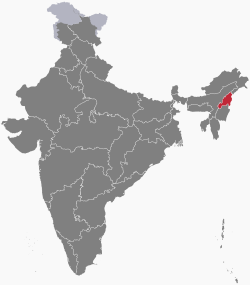
Nagaland /ˈnɑːɡəlænd/ is a state in Northeast India. It borders the state of Assam to the west, Arunachal Pradesh and part of Assam to the north, Burma to the east, and Manipur to the south. The state capital is Kohima, and the largest city is Dimapur. It has an area of 16,579 square kilometres (6,401 sq mi) with a population of 1,980,602 per the 2011 Census of India, making it one of the smallest states of India.
The state is inhabited by 17 major tribes — Ao, Angami, Chang, Konyak, Lotha, Sumi, Chakhesang, Khiamniungan, Dimasa Kachari, Phom, Rengma, Sangtam, Yimchunger, Kuki, Zeme-Liangmai (Zeliang) Pochury and Rongmei as well as sub-tribes. Each tribe is unique in character with its own distinct customs, language and dress.
...
Wikipedia

