Manipur
|
Manipur মনিপুর |
||
|---|---|---|
| State | ||
|
||
 |
||
| Coordinates (imphal): 24°49′01″N 93°57′00″E / 24.817°N 93.95°ECoordinates: 24°49′01″N 93°57′00″E / 24.817°N 93.95°E | ||
| Country |
|
|
| Formation | 21 January 1972 | |
| Capital | Imphal | |
| Districts | 16 | |
| Government | ||
| • Governor | Najma Heptulla | |
| • Chief Minister | Okram Ibobi Singh (INC) | |
| • Legislature | Unicameral (60 seats) | |
| • Parliamentary constituency |
Rajya Sabha 1 Lok Sabha 2 |
|
| • High Court | Manipur High Court | |
| Area | ||
| • Total | 22,327 km2 (8,621 sq mi) | |
| Area rank | 24th | |
| Population (2011) | ||
| • Total | 2,855,794 | |
| • Rank | 24th | |
| • Density | 130/km2 (330/sq mi) | |
| Time zone | IST (UTC+05:30) | |
| ISO 3166 code | IN-MN | |
| HDI |
|
|
| HDI rank | 5th (2005) | |
| Literacy | 79.21% (2011 Census) | |
| Official language | Manipuri | |
| Website | www.manipur.gov.in | |
| It elevated from the status of Union-Territories by the North-Eastern Areas (Reorganisation) Act 1971 | ||
| Emblem | Kaglasha |
|---|---|
| Animal | Sangai |
| Bird | Nongyen |
| Flower | Siroi Lily |
| Tree | Uningthou |
| Game | Manipuri Polo |
| Population Growth | |||
|---|---|---|---|
| Census | Pop. | %± | |
| 1951 | 578,000 |
—
|
|
| 1961 | 780,000 | 34.9% | |
| 1971 | 1,073,000 | 37.6% | |
| 1981 | 1,421,000 | 32.4% | |
| 1991 | 1,837,000 | 29.3% | |
| 2001 | 2,294,000 | 24.9% | |
| 2011 | 2,855,794 | 24.5% | |
| Source:Census of India | |||
| Demographics of Manipur (2001) | |
|---|---|
| Total Population | 2,388,634 |
| Male Population | 1,207,338 |
| Female Population | 1,181,296 |
| Rural Population | 1,818,224 |
| Urban Population | 570,410 |
| Child Sex Ratio | 978 female to 1000 male |
| Density (per km2) | 107 |
| Literacy | 1,429,656 (68.87%) |
| Towns | 33 |
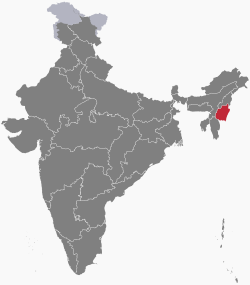
Manipur (English pronunciation: ![]() i/ˌmənɪpʊr/) is a state in northeastern India, with the city of Imphal as its capital. Manipur is sometimes called alternative names such as Kangleipak or Sanaleibak. It is bounded by Nagaland to the north, Mizoram to the south, and Assam to the west; Burma (Myanmar) lies to its east. The state covers an area of 22,327 square kilometres (8,621 sq mi) and has a population of almost 3 million, including the Meetei, Kuki, Naga, and Pangal peoples, who speak Sino-Tibetan languages. Manipur has been at the crossroads of Asian economic and cultural exchange for more than 2,500 years. It has long connected the Indian subcontinent to Southeast Asia, enabling migration of people, cultures and religions.
i/ˌmənɪpʊr/) is a state in northeastern India, with the city of Imphal as its capital. Manipur is sometimes called alternative names such as Kangleipak or Sanaleibak. It is bounded by Nagaland to the north, Mizoram to the south, and Assam to the west; Burma (Myanmar) lies to its east. The state covers an area of 22,327 square kilometres (8,621 sq mi) and has a population of almost 3 million, including the Meetei, Kuki, Naga, and Pangal peoples, who speak Sino-Tibetan languages. Manipur has been at the crossroads of Asian economic and cultural exchange for more than 2,500 years. It has long connected the Indian subcontinent to Southeast Asia, enabling migration of people, cultures and religions.
During the British Rule, the Kingdom of Manipur was one of the princely states. Between 1917 and 1939, the people of Manipur pressed for their rights against the British Rule. By the late 1930s, the princely state of Manipur negotiated with the British administration its preference to be part of India, rather than Burma. These negotiations were cut short with the outbreak of World War II. On 21 September 1949, Maharaja Budhachandra signed a Treaty of Accession merging the kingdom into India. This merger is disputed by groups in Manipur as having been completed without consensus and under duress. The dispute and differing visions for the future has resulted in a 50-year insurgency in the state for independence from India, as well as in violence between ethnic groups in the state. Over 2010–2013, the militant insurgency was responsible for the violent death of about 1 civilian per 100,000 people, each year. The world average annual death rate from intentional violence has been 7.9 per 100,000 people.
...
Wikipedia

