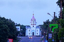
Kobeliaky
|
Kobeliaky Кобеляки |
|||
|---|---|---|---|

Church in Kobeliaky
|
|||
|
|||
| Location of Kobeliaky | |||
| Coordinates: 49°08′00″N 34°12′00″E / 49.13333°N 34.20000°ECoordinates: 49°08′00″N 34°12′00″E / 49.13333°N 34.20000°E | |||
|
Country Oblast Raion |
Poltava Oblast Kobeliaky Raion |
||
| Founded | 1620 | ||
| Area | |||
| • Total | 1.21 km2 (0.47 sq mi) | ||
| Elevation | 80 m (260 ft) | ||
| Population (2015) | |||
| • Total | 9,977 | ||
| Time zone | EET (UTC+2) | ||
| • Summer (DST) | EEST (UTC+3) | ||
| Postal code | 39200—39204 | ||
| Vehicle registration | BI | ||
Kobeliaky (Ukrainian: Кобеляки) is a city in Poltava Oblast, Ukraine. Population is 9,977 (2015 est.).
During World War II, Kobeliaky was under German occupation from 15 September 1941 until 25 September 1943.
Historical building in Kobeliaky
Bus station
Shops in Kobeliaky
...
Wikipedia


