Kireçburnu, Sarıyer
| Kireçburnu | |
|---|---|
| Neighborhood | |

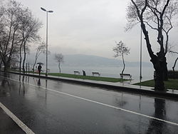
A view from the Bosphorus shore at Kireçburnu.
|
|
| Coordinates: 41°08′33″N 29°02′45″E / 41.14250°N 29.04583°ECoordinates: 41°08′33″N 29°02′45″E / 41.14250°N 29.04583°E | |
| Country |
|
| Region | Marmara |
| Province | Istanbul |
| District | Sarıyer |
| Time zone | EET (UTC+2) |
| • Summer (DST) | EEST (UTC+3) |
| Postal code | 34457 |
| Area code | 0–212 |
Kireçburnu is a neighborhood of Sarıyer district in Istanbul Province, Turkey. It is located on the northern shore of Bosphorus at European side... Siteated at about 41°08′N 29°03′E / 41.133°N 29.050°E, It is to the north of İstanbul centrum with a distance over 15 kilometres (9.3 mi).
During the Byzantine Empire era Kireçburnu was a village named Kleidai tou Pontou. During the construction of Rumeli Castle by the Ottoman Sultan Mehmet II, the limekilns in the village were used as the construction material of the castle. Turkish for lime is kireç and for cape is burun and eventually the village was called Kireçburnu. As the urban fabrik of İstanbul expanded Kireçburnu became a neighborhood of the city. During the 19th century Kireçburnu was full of foreign embassies to the Ottoman Empire. Presently one of the most important buildings is the big mansion which was a gift from the Ottoman sultan Abdülhamit II to Italian king Victor Emmanuel III and his wife Montenigrin princes Elena. The building now a property of the Italian embassy is under construction.
Kireçburnu is bordered by Tarabya in the south. The neighborhood is well known for its fish food reataurants.
The local sports club Kireçburnu Spor is active in football only. Its women's team was promoted from the Second League to the Turkish Women's First Football League for the 2015–16 season.
...
Wikipedia

