Sarıyer
| Sarıyer | |
|---|---|
| district | |

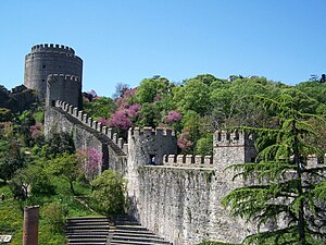
Rumelihisarı in Sarıyer
|
|
 Location of Sarıyer in Istanbul |
|
| Location of Sarıyer in Istanbul | |
| Coordinates: 41°11′28″N 29°00′34″E / 41.19111°N 29.00944°ECoordinates: 41°11′28″N 29°00′34″E / 41.19111°N 29.00944°E | |
| Country | Turkey |
| City | Istanbul |
| Government | |
| • Mayor | Şükrü Genç (CHP) |
| • Governor | Mehmet Ersoy |
| Area | |
| • District | 161.92 km2 (62.52 sq mi) |
| Population (2012) | |
| • Urban | 258,035 |
| • District | 289,959 |
| • District density | 1,800/km2 (4,600/sq mi) |
| Time zone | EET (UTC+2) |
| • Summer (DST) | EEST (UTC+3) |
| Area code(s) | 0–212 |
| Website |
www |
Sarıyer (pronounced [saˈɾɯjeɾ]) is the northernmost district of Istanbul, Turkey, on the European side of the city. With a long shore along the water, the district boasts both a beautiful coastline and a lush forest. The Sarıyer district is a huge area consisting of the villages on the European side of the Bosphorus from Rumelifeneri, down through Tarabya, Yeniköy, İstinye, Emirgan to Rumelihisarı. Sarıyer also administers the Black Sea coast to the west of the mouth of the Bosphorus including the village of Kilyos. Its neighbours are Eyüp the northwest, Beşiktaş the south and Kağıthane the west. Sarıyer has a population of approximately 260,000. The mayor is Şükrü Genç (CHP). Some parts of Beyoğlu and Çatalca was joined and Sarıyer became district centre in 1930. District boundaries were shrunk after county of Kemerburgaz was given to Eyüp in 1936 and villages of Maslak and Ayazağa were given to Şişli in 1954. Sarıyer has present boundaries after joining boroughs of Maslak, Ayazağa and Huzur from Şişli district in 2012.
Sarıyer's Bosphorus villages, backed by steep hills, were once rural fishing communities. They later became retreats for the city's wealthy. In the Ottoman period the sultans came to these villages for picnics and excursions. During the 18th and 19th centuries, the coast was lined with summer residences of the wealthy foreign traders of Pera and Galata. Many foreign embassies built summer residences in this period. Since the construction of the coast road, these villages, and increasingly the hillsides behind them, house many expensive villas owned by İstanbul's rich businessmen, actors and musicians, attracted by the coastline and the lush forest behind.
...
Wikipedia

