Kielce Voivodeship (1919–39)
| Kielce Voivodeship Województwo kieleckie |
|||||
| Voivodeship of Poland | |||||
|
|||||
|
Coat of arms |
|||||
|
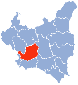
Location of the Kielce Voivodeship (red) within the Second Polish Republic, 1938. |
|||||
| Capital | Kielce | ||||
| Government | Voivodeship | ||||
| Voivode | |||||
| • | 1919–1923 | Stanisław Franciszek Pękosławski | |||
| • | 1934–1939 | Władysław Dziadosz | |||
| History | |||||
| • | Established | 14 August 1919 | |||
| • | Annexed by Germany | September 1939 | |||
| Area | |||||
| • | 1921 | 25,741 km2(9,939 sq mi) | |||
| • | 1939 | 22,204 km2(8,573 sq mi) | |||
| Population | |||||
| • | 1921 | 2,535,898 | |||
| Density | 98.5 /km2 (255.2 /sq mi) | ||||
| • | 1931 | 2,671,000 | |||
| Political subdivisions | 18 powiats | ||||
Coat of arms
Kielce Voivodeship (Polish: województwo kieleckie) - a unit of administrative division and local government in Poland in years 1921–1939. At that time, it covered northern counties of the historic province of Lesser Poland, including such cities as Radom, and Sosnowiec. On April 1, 1938, its borders changed, see: Territorial changes of Polish Voivodeships on April 1, 1938. Capital city: Kielce.
In early 1939, Voivodeship's area was 22 204 square kilometers. It was located in central Poland, bordering Germany and Autonomous Silesian Voivodeship to the west, Łódź Voivodeship and Warsaw Voivodeship to the north, Lublin Voivodeship and Lwów Voivodeship to the east and Kraków Voivodeship to the south. Landscape was flat in the northern part and hilly in mid and south, with the Swietokrzyskie Mountains located in the heart of the area. Forests covered 21.2%, with the national average 22.2% (as for January 1, 1937).
...
Wikipedia


