Khasan District
| Khasansky District Хасанский район (Russian) |
|
|---|---|
 Location of Khasansky District in Primorsky Krai |
|
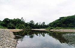
 The Poyma River in Khasansky District |
|
| Location | |
| Country | Russia |
| Federal subject | Primorsky Krai |
| Administrative structure (as of June 2012) | |
| Administrative center | urban-type settlement of Slavyanka |
| Inhabited localities: | |
| Urban-type settlements | 6 |
| Rural localities | 31 |
| Municipal structure (as of December 2004) | |
| Municipally incorporated as | Khasansky Municipal District |
| Municipal divisions: | |
| Urban settlements | 6 |
| Rural settlements | 2 |
| Statistics | |
| Area | 4,130.0 km2 (1,594.6 sq mi) |
| Population (2010 Census) | 35,541 inhabitants |
| • Urban | 70.5% |
| • Rural | 29.5% |
| Density | 8.61/km2 (22.3/sq mi) |
| Time zone | VLAT (UTC+10:00) |
| Official website | |
| on | |
Khasansky District (Russian: Хаса́нский райо́н) is an administrative and municipal district (raion), one of the twenty-two in Primorsky Krai, Russia. It is located in the southwest of the krai, wedged between the Tumen River and the Peter the Great Gulf, and shares a border with both China and North Korea. The area of the district is 4,130.0 square kilometers (1,594.6 sq mi). Its administrative center is the urban locality (an urban-type settlement) of Slavyanka. Population: 35,541 (2010 Census);37,459 (2002 Census);43,709 (1989 Census). The population of Slavyanka accounts for 39.5% of the district's total population.
A significant part of the area is protected by the laws of Russia. The nature reserves include Kedrovaya Pad, established to protect the rare animals of South Primorye such as Amur leopard, Siberian tiger, and Siberian Musk Deer; and the Far Eastern Marine Nature Reserve (1978), protecting the underwater world of the Peter the Great Gulf, including more than two thousand species of invertebrate animals (such as sea cucumber), approximately three hundred fish species, and larga seals.
...
Wikipedia
