Kharsawan State
| Kharsawan State ଖରସୁଆଁ - kharaswan |
|||||
| Princely State of British India | |||||
|
|||||
|
Flag |
|||||
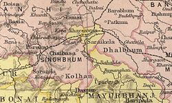
| Kharsawan State in a 1909 Imperial Gazetteer of India map | |||||
| History | |||||
| • | Established | 1650 | |||
| • | Independence of India | 1948 | |||
| Area | |||||
| • | 1892 | 396 km2(153 sq mi) | |||
| Population | |||||
| • | 1892 | 31,051 | |||
| Density | 78.4 /km2 (203.1 /sq mi) | ||||
Flag
Kharsawan State, also spelt Kharsua or kharaswan, was a princely state in India during the era of the British Raj. The state had a privy purse of 33,000 Rs. and was one of the nine Chota Nagpur States under the authority of the governor of Bengal Presidency. It was one of the Odia Princely states of India during the period of the British Raj and the major language spoken in the area is Odia.
The capital was the city of Kharsawan and the former area of Kharsawan State is now a part of Jharkhand, where its district is named Seraikela Kharsawan district. Kumar Aditya Narayan Singh Deo and his father Maharaj Kumar Rudra Pratap Singh Deo appreciated the name change of the district.
Kharsawan estate was founded in 1650. The rulers of Kharsawan are descended from Kunwar Bikram Singh of Porahat, the first ruler of neighbouring Seraikela State. His second son, Kunwar Padam Singh was the founder of Kharsawan. In 1857 Kharsawan estate was recognized as a state.
In 1912 Kharsawan came under the authority of the province of Bihar and Orissa, which had been carved from the eastern districts of Bengal. In 1936 the state was placed under the authority of the Orissa Province. Saraikela, along with 24 other princely states of the Eastern States Agency, acceded to the Government of India on 1 January 1948, with a will to merge the princely state with Orissa province of the Indian Republic.
...
Wikipedia


