Kerr County, Texas
| Kerr County, Texas | |
|---|---|

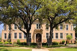
Kerr County Courthouse, southside view
|
|
 Location in the U.S. state of Texas |
|
 Texas's location in the U.S. |
|
| Founded | 1856 |
| Named for | James Kerr |
| Seat | Kerrville |
| Largest city | Kerrville |
| Area | |
| • Total | 1,107 sq mi (2,867 km2) |
| • Land | 1,103 sq mi (2,857 km2) |
| • Water | 4.0 sq mi (10 km2), 0.4% |
| Population | |
| • (2010) | 49,625 |
| • Density | 45/sq mi (17/km²) |
| Congressional district | 21st |
| Time zone | Central: UTC-6/-5 |
| Website | www |
Kerr County is a county located on the Edwards Plateau in the U.S. state of Texas. As of the 2010 census, its population was 49,625. Its county seat is Kerrville. The county was named by Joshua D. Brown for his fellow Kentucky native, James Kerr, a congressman of the Republic of Texas.
The Kerrville, TX Micropolitan Statistical Area includes all of Kerr County.
Around 8000 BC, early Native American inhabitants arrived in the area, with numerous successive cultures following in prehistoric times. Historic tribes encountered by Europeans included the Kiowa, Comanche, and Lipan Apache.
In 1842, the AdelsvereinFisher-Miller Land Grant set aside 3,000,000 acres (12,000 km²) to settle 600 families and single men of German, Dutch, Swiss, Danish, Swedish, and Norwegian ancestry in Texas.Henry Francis Fisher sold his interest in the land grant to the Adelsverein in 1844.
In 1845, Prince Carl of Solms-Braunfels secured the title to 1,265 acres (5.12 km2) of the Veramendi grant, including the Comal Springs and River, for the Adelsverein. Thousands of German immigrants were stranded at port of disembarkation, Indianaola on Matagorda Bay. With no food or shelter, living in holes dug into the ground, an estimated 50% died from disease or starvation.Joshua Brown, in 1846, became the first settler.
...
Wikipedia
