Keltzene
| Erzincan | |
|---|---|
| Municipality | |

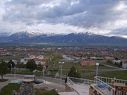
View of Erzincan
|
|
| Coordinates: 39°44′47″N 39°29′29″E / 39.74639°N 39.49139°ECoordinates: 39°44′47″N 39°29′29″E / 39.74639°N 39.49139°E | |
| Country | Turkey |
| Province | Erzincan |
| Government | |
| • Mayor | Cemalettin Başsoy (AKP) |
| Area | |
| • District | 1,622.08 km2 (626.29 sq mi) |
| Elevation | 1,185 m (3,888 ft) |
| Population (2012) | |
| • Urban | 96,474 |
| • District | 144,545 |
| • District density | 89/km2 (230/sq mi) |
| Website | www.erzincan.bel.tr |
Erzincan (pronounced [eɾˈzindʒan]) (Armenian: Երզնկա, Yerznka) is the capital of Erzincan Province in northeastern Turkey. Nearby cities include Erzurum, Sivas, Tunceli, Bingöl, Elâzığ, Malatya, Gümüşhane, Bayburt, and Giresun. Located at an altitude of 1,185 meters above sea level, the city's climate produces snowy winters and warm summers.
The city is notable for handcrafted copper goods and a special cheese called "tulum peyniri" in Turkish. It is a significant road and rail junction and was once noted for its silverware. Current industries include sugar refining and textile industries. The city is home to the headquarters of the Turkish Third Army.
Acilisene, the ancient city that is now Erzincan, was the site of the Peace of Acilisine by which in AD 387 Armenia was divided into two vassal states, a smaller one dependent on the Byzantine Empire and a larger one dependent on Persia. This is the name (Ἀκιλισηνή in Greek) by which it is called by Strabo in his Geography, 11.4.14. The etymological origin of the word is disputed, but it is agreed that the city was once called Erez. For a while it was called Justinianopolis in honour of Emperor Justinian. In more recent Greek it has been called as Κελτζηνή (Celtzene) and Κελεζηνή (Celezene)
...
Wikipedia

