Katonah
| Katonah, New York | |
|---|---|
| CDP | |

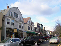
Looking north along Katonah Avenue
|
|
| Location within the state of New York | |
| Coordinates: 41°15′31″N 73°41′7″W / 41.25861°N 73.68528°WCoordinates: 41°15′31″N 73°41′7″W / 41.25861°N 73.68528°W | |
| Country | United States |
| State | New York |
| County | Westchester |
| Town | Bedford |
| Area | |
| • Total | 0.8 sq mi (2.1 km2) |
| • Land | 0.7 sq mi (1.9 km2) |
| • Water | 0.08 sq mi (0.2 km2) |
| Elevation | 235 ft (72 m) |
| Population (2010) | |
| • Total | 1,679 |
| • Density | 2,289/sq mi (883.7/km2) |
| Time zone | Eastern (EST) (UTC-5) |
| • Summer (DST) | EDT (UTC-4) |
| ZIP code | 10536 |
| Area code(s) | 914 Exchanges: 232,766,767 |
| FIPS code | 36-38946 |
| GNIS feature ID | 0954396 |
| Website | www |
Katonah is one of three hamlets and census-designated places (CDP) within the town of Bedford, Westchester County, in the U.S. state of New York, specifically northern Westchester. The Katonah CDP had a population of 1,679 at the 2010 census.
Katonah is named for Chief Katonah, an American Indian from whom the land of Bedford was purchased by a group of English colonists. Founded with the name Whitlockville, the town changed its name, and later was moved to its present site in 1897, when its former site (Old Katonah) was flooded by the construction of the Cross River Reservoir. More than 50 buildings were moved from the old site to New Katonah, rolled on logs pulled by horses. The move was originally ordered to start in 1894, but litigation delayed the process by almost three years.
Eleven-year-old child named B. Robertson wrote the following to a children magazine on March 2nd, 1897:
Katonah was not the only village affected by New York City's growing demand for water. The villages of Kirbyville and New Castle Corners were also condemned by the city but were never moved.
During the American Revolution military battles or skirmishes did not take place in the area that is now the Village of Katonah. However, most local men joined the Continental side, with some joining the New York 4th Regiment of the Line and most joining the local Militia. Though the Bedford Township lay in what was called "Neutral Ground", supposedly not molested by military of either side, its inhabitants were preyed on by the lawless of both sides. Actually, this area suffered less from lawless depredations than other areas in the Neutral Ground, because of the proximity of the Croton River and the "Westchester Lines", a sparse string of outposts defended by units of the Continental Army.
The Katonah Village Historic District, and St. Luke's Episcopal Church are listed on the National Register of Historic Places. The John Jay Homestead and Stepping Stones, home of Bill and Lois Wilson, received the designation of National Historic Landmark.
...
Wikipedia

