Kastamonu Province
|
Kastamonu Province Kastamonu ili |
|
|---|---|
| Province of Turkey | |
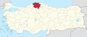
 Location of Kastamonu Province in Turkey |
|
| Country | Turkey |
| Region | West Black Sea |
| Subregion | Kastamonu |
| Government | |
| • Electoral district | Kastamonu |
| Area | |
| • Total | 13,108 km2 (5,061 sq mi) |
| Population (2010) | |
| • Total | 361,222 |
| • Density | 28/km2 (71/sq mi) |
| Area code(s) | 0366 |
| Vehicle registration | 37 |
Kastamonu Province (Turkish: Kastamonu ili) is one of the provinces of Turkey, in the Black Sea region to the north of the country. It is surrounded by Sinop to the east, Bartın, Karabük to the west, Çankırı to the south, Çorum to the southeast and the Black Sea to the north.
The province has an area of 13,108 km², and a population of 322,759 people (2006 est). The population was 361,222 people in 2010. The population density is 24.62 inhabitants per km². The province center has a population of 64,606.
Kastamonu province is divided into 20 districts (capital district in bold):
It is not definitively known when Kastamonu was first founded. However, some sources dating back to the Early Middle Ages refer to the province. There are also some archeological findings that date to about 100,000 years that suggest the region was inhabited at that time.
There are theories that the word Kastamonu derives from Castra Comnenus, the Latin name of the Byzantine castle built by the Comnenus dynasty.
With the weakening of the Macedon kings, the Paphlagonia and Bithynia regions were engulfed by the newly formed Pontus kingdom. After the fall of the Pontus kingdom in first century BC, the area was incorporated by the Roman Empire by joining Paphlagonia with Bithynia. The capital center of this new city-state was Pompeiopolis, of which the remains still stand near Tasköprü District in Kastamonu.
...
Wikipedia
