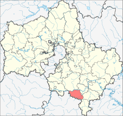
Kashirsky District, Moscow Oblast
| Kashirsky District Каширский район (Russian) |
|
|---|---|
 Location of Kashirsky District in Moscow Oblast (before July 2012) |
|
| Coordinates: 54°50′N 38°09′E / 54.833°N 38.150°ECoordinates: 54°50′N 38°09′E / 54.833°N 38.150°E | |
 View of the Oka River, from Kashira, Kashirsky District |
|
|
|
|
| Location | |
| Country | Russia |
| Federal subject | Moscow Oblast |
| Administrative structure (as of January 2013) | |
| Administrative center | town of Kashira |
| Administrative divisions: | |
| Towns | 2 |
| Rural settlements | 5 |
| Inhabited localities: | |
| Cities/towns | 2 |
| Rural localities | 96 |
| Municipal structure (as of December 2010) | |
| Municipally incorporated as | Kashirsky Municipal District |
| Municipal divisions: | |
| Urban settlements | 2 |
| Rural settlements | 5 |
| Statistics | |
| Area (municipal district) (December 2010) | 646.09 km2 (249.46 sq mi) |
| Population (2010 Census) | 70,269 inhabitants |
| • Urban | 74.5% |
| • Rural | 25.5% |
| Density | 108.76/km2 (281.7/sq mi) |
| Time zone | MSK (UTC+03:00) |
| Official website | |
| on | |
Kashirsky District (Russian: Каши́рский райо́н) is an administrative and municipal district (raion), one of the thirty-six in Moscow Oblast, Russia. It is located in the south of the oblast. The area of the district is 646.09 square kilometers (249.46 sq mi). Its administrative center is the town of Kashira. Population: 70,269 (2010 Census); 70,774 (2002 Census);35,300 (1989 Census). The population of Kashira accounts for 59.6% of the district's total population.
...
Wikipedia

