Kangri Garpo
| Kangri Garpo | |
|---|---|
| 岗日嘎布 | |

|
|
| Highest point | |
| Peak | Bairiga |
| Elevation | 6,882 m (22,579 ft) |
| Coordinates | 29°09′57″N 96°43′27″E / 29.16583°N 96.72417°ECoordinates: 29°09′57″N 96°43′27″E / 29.16583°N 96.72417°E |
| Geography | |
| Country | China |
| Province | Tibet Autonomous Region |
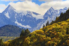
Kangri Garpo (Chinese: 岗日嘎布; pinyin: Gǎngrì Gābù) is a mountain range in eastern Tibet, located primarily in Nyingchi Prefecture as well as a portion of Qamdo Prefecture in the Tibet Autonomous Region, China. The mountain range lies to the east of the Himalayas and to the west of the Hengduan Mountains. The mountains are geographically a southern extension of the eastern Transhimalayas.
The Kangri Garpo stretch for approximately 280 km (170 mi) from west to east. They lie at the eastern end of the Himalayan Range and were formed at the same time during the Indian subcontinent's collision with Eurasia. The Kangri Garpo are geologically related to the Himalayas, but are separated by the Yarlung Tsangpo's Grand Canyon. The eastern anchor of the Himalayas, Namcha Barwa, rises above the western Kangri Garpo just beyond the Yarlung Tsangpo. The the north, the Kangri Garpo are separated from the Nyenchen Tanglha by the Parlung Tsangpo River. To the northeast, the Kangri Garpo are connected with the Baxoila Range, sometimes considered the westernmost component range of the Hengduan Mountains. Further east, the Kangri Garpo are separated from the Baxoila by the Zayü River. To the south, the Kangri Garpo transition to the Indian Mishmi Hills, also known in China as the Qilinggong Mountains (祁灵公山). The distinction between the Kangri Garpo and the Mishmi Hills is not well defined, and may only represent a difference of cultures on either on either side of the McMahon Line.
...
Wikipedia
