Namcha Barwa
| Namcha Barwa | |
|---|---|

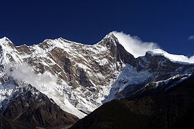
Namcha Barwa from the west, from Zhibai observation platform
|
|
| Highest point | |
| Elevation | 7,782 m (25,531 ft) Ranked 28th |
| Prominence | 4,106 m (13,471 ft) Ranked 19th |
| Isolation | 708 kilometres (440 mi) |
| Listing | Ultra |
| Coordinates | 29°37′45″N 95°03′21″E / 29.62917°N 95.05583°ECoordinates: 29°37′45″N 95°03′21″E / 29.62917°N 95.05583°E |
| Geography | |
| Location |
Tibet Nyingchi Prefecture Mêdog County north of McMahon Line |
| Parent range |
Himalayas Namcha Barwa Himal |
| Climbing | |
| First ascent | 1992, China–Japan expedition |
| Easiest route | SSW ridge on rock, snow and ice |
Namcha Barwa or Namchabarwa (Tibetan: གནམས་ལྕགས་འབར་བ།, Wylie: Gnams lcags 'bar ba, ZYPY: Namjagbarwa; Chinese: 南迦巴瓦峰, Pinyin: Nánjiābāwǎ Fēng) is a mountain in the Tibetan Himalaya. The traditional definition of the Himalaya extending from the Indus River to the Brahmaputra would make it the eastern anchor of the entire mountain chain, and it is the highest peak of its own section as well as Earth's easternmost peak over 7,600 metres.
Namcha Barwa is in an isolated part of southeastern Tibet rarely visited by outsiders. It stands inside the Great Bend of the Yarlung Tsangpo River as the river enters its notable gorge across the Himalaya, emerging as the Siang and becoming the Brahmaputra. Namcha Barwa's sister peak Gyala Peri 7,294 metres rises across the gorge 22 km to the NNW.
Namcha rises 5,000 to 6,800 metres above the Yarlung Tsangpo. After 7,795 metre Batura Sar in the Karakoram was climbed in 1976, Namcha Barwa became the highest unclimbed independent mountain in the world, until it was finally climbed in 1992.
...
Wikipedia

