Kanchanaburi Province
|
Kanchanaburi กาญจนบุรี |
||
|---|---|---|
| Province | ||

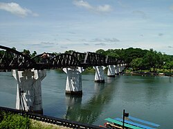
Bridge over River Kwai
|
||
|
||
 Map of Thailand highlighting Kanchanaburi Province |
||
| Country | Thailand | |
| Capital | Kanchanaburi | |
| Government | ||
| • Governor | Sak Sombunto (since October 2015) | |
| Area | ||
| • Total | 19,483 km2 (7,522 sq mi) | |
| Area rank | Ranked 3rd | |
| Population (2014) | ||
| • Total | 848,198 | |
| • Rank | Ranked 26th | |
| • Density | 44/km2 (110/sq mi) | |
| • Density rank | Ranked 74th | |
| HDI | ||
| • HDI (2009) | 0.733 (medium) (40th) | |
| Time zone | ICT (UTC+7) | |
| Area code(s) | 034 | |
| ISO 3166 code | TH-71 | |
| Vehicle registration | กาญจนบุรี | |
Kanchanaburi (Thai: กาญจนบุรี, pronounced [kāːn.t͡ɕā.ná(ʔ).bū.rīː]) is the largest of the western provinces (changwat) of Thailand. The neighboring provinces are (clockwise, from the north) Tak, Uthai Thani, Suphan Buri, Nakhon Pathom, and Ratchaburi. In the west it borders Kayin State, Mon State, and the Tanintharyi Region of Myanmar.
Tourists are attracted by the history of its ancient civilization and the World War II Bridge over the River Kwai (also spelt "Khwae").
The province is in the west of Thailand, 129 km from Bangkok, and covers a total area of approximately 19,483 km². It is the country's third largest province, after Nakhon Ratchasima and Chiang Mai. Topographically, it is covered with timber and evergreen forests. The district covers the source valleys of the rivers Kwae Yai and Kwae Noi ("River Kwai"), which merge at Kanchanaburi city to form the Mae Klong River.
Bong Ti is a transnational border crossing point, which is expected to gain in importance if the planned Dawei deepwater port project goes ahead, along with a highway and a railway line between Bangkok and the port.
Several national parks are in the mountainous forest areas of the Tenasserim Hills of the province: the Erawan, Sai Yok, Khao Laem, Thong Pha Phum, Khuean Srinagarindra, and Chaloem Rattanakosin National Parks. The Thungyai Naresuan Wildlife Sanctuary is on the UNESCO world heritage list.
...
Wikipedia

