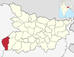
Kaimur District
|
Kaimur district कैमूर ज़िला |
|
|---|---|
| district | |
 |
|
| Country |
|
| State | Bihar |
| Administrative Division | Patna Division |
| Headquarters | Bhabua |
| Area | |
| • Total | 8,268 km2 (3,192 sq mi) |
| Population (2011) | |
| • Total | 1,626,384 |
| Languages:Bhojpuri and Tehti(Hindi) | |
| Time zone | IST (UTC+5:30) |
| ISO 3166 code | IN-BR |
| Lok Sabha | Sasaram |
| Website | http://www.kaimur.bih.nic.in/ |
Kaimur district is one of the thirty-eight districts of Bihar state, India. The district headquarters are located at Bhabua. Before 1991, it was part of Rohtas District, Bihar.
The district occupies an area of 3363 km² and has a population of 1,626,384 (as of 2011[update]) with the rank of 307th in the country. The district has a Literacy rate of 69.34% (392nd in the country). Kaimur district is a part of Patna division. It is the westernmost district of Bihar, western point of Bihar called Chand is situated on the Bhabua-Chandauli road. The district has 18 Colleges, 58 High Schools, 146 Middle Schools and 763 Primary Schools. The district has a total no. of 1699 villages. The district also has 120 Post Offices and 151 Panchayats.
Kaimur district was established in March 1991. It was sectioned off from the Rohtas district. The earliest evidence of human habitation in the district consists of rock paintings in the Lehda forest that date to around 20,000 years ago. In June 2012, erotic Pala sculptures were excavated in the village of Baidyanath.
It is currently a part of the Red Corridor.
Kaimur district occupies an area of 3,362 square kilometres (1,298 sq mi), comparatively equivalent to Russia's Vaygach Island.
The Kaimur Range and Rohtas Plateau cover the southern part of this district. The Karmnasha and Durgawati rivers run through the district. A large forest covers part of Kaimur; it measures 1,06,300 hectares and contains the Kaimur Wildlife Sanctuary which is home to tigers, leopards and chinkaras.
...
Wikipedia
