Junk Ceylon
|
Phuket ภูเก็ต |
||
|---|---|---|
| Province | ||
|
||
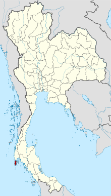
 Map of Thailand highlighting Phuket Province |
||
| Country | Thailand | |
| Capital | Phuket City | |
| Government | ||
| • Governor | Noraphat Plotthong (since April 2017) | |
| Area | ||
| • Total | 576 km2 (222 sq mi) | |
| Area rank | Ranked 75th | |
| Population (2015) | ||
| • Total | 386,605 | |
| • Rank | Ranked 68th | |
| • Density | 1,042/km2 (2,700/sq mi) | |
| • Density rank | Ranked 6th | |
| Time zone | ICT (UTC+7) | |
| ISO 3166 code | TH-83 | |

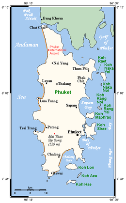
Map of Phuket (beaches in brown)
|
|
| Geography | |
|---|---|
| Location | Andaman Sea |
| Coordinates | 7°53′24″N 98°23′54″E / 7.89000°N 98.39833°E |
| Area | 576 km2 (222 sq mi) |
| Length | 50 km (31 mi) |
| Width | 20 km (12 mi) |
| Highest elevation | 529 m (1,736 ft) |
| Highest point | Khao Mai Thao Sip Song |
| Administration | |
|
Thailand
|
|
| Demographics | |
| Population | 386,605 (2015) |
| Pop. density | 1,042 /km2 (2,699 /sq mi) |
Phuket (Thai: ภูเก็ต, [pʰūː.kèt] (![]() listen), Malay: Talang or Tanjung Salang) is one of the southern provinces (changwat) of Thailand. It consists of the island of Phuket, the country's largest island, and another 32 smaller islands off its coast. It lies off the west coast of Thailand in the Andaman Sea. Phuket Island is connected by the Sarasin Bridge to Phang Nga Province to the north. The next nearest province is Krabi, to the east across Phang Nga Bay.
listen), Malay: Talang or Tanjung Salang) is one of the southern provinces (changwat) of Thailand. It consists of the island of Phuket, the country's largest island, and another 32 smaller islands off its coast. It lies off the west coast of Thailand in the Andaman Sea. Phuket Island is connected by the Sarasin Bridge to Phang Nga Province to the north. The next nearest province is Krabi, to the east across Phang Nga Bay.
Phuket Province has an area of 576 square kilometres (222 sq mi), somewhat less than that of Singapore, and is the second-smallest province of Thailand. It formerly derived its wealth from tin and rubber, and enjoys a rich and colorful history. The island was on one of the major trading routes between India and China, and was frequently mentioned in foreign ship logs of Portuguese, French, Dutch, and English traders. The region now derives much of its income from tourism.
...
Wikipedia

