Jourdanton, Texas
| Jourdanton, Texas | |
|---|---|
| City | |

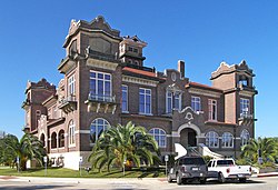
Atascosa County Courthouse
|
|
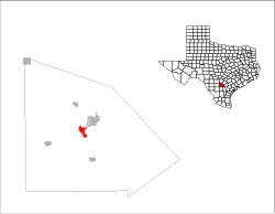
 Location of Jourdanton, Texas |
|
 |
|
| Coordinates: 28°55′18″N 98°32′47″W / 28.92167°N 98.54639°WCoordinates: 28°55′18″N 98°32′47″W / 28.92167°N 98.54639°W | |
| Country | United States |
| State | Texas |
| County | Atascosa |
| Area | |
| • Total | 3.5 sq mi (9.1 km2) |
| • Land | 3.5 sq mi (9.1 km2) |
| • Water | 0.0 sq mi (0.0 km2) |
| Elevation | 459 ft (140 m) |
| Population (2010) | |
| • Total | 3,871 |
| • Density | 1,100/sq mi (430/km2) |
| Time zone | Central (CST) (UTC-6) |
| • Summer (DST) | CDT (UTC-5) |
| ZIP code | 78026 |
| Area code(s) | 830 |
| FIPS code | 48-38116 |
| GNIS feature ID | 1360436 |
Jourdanton (/ˈdʒɜːrdəntən/ JUR-dən-tən) is a city in and the county seat of Atascosa County, Texas, United States. The population was 3,871 at the 2010 census. It is part of the San Antonio Metropolitan Statistical Area. The Mayor is Robert "Doc" Williams. The City Manager is Kendall Schorsch. The Police Chief is Eric Kaiser. The Volunteer Fire Chief is David Prasifka.
Jourdanton was founded in 1909 and was named after founder Jourdan Campbell. The county seat was moved from Pleasanton to Jourdanton in 1910.
Jourdanton is located near the center of Atascosa County at 28°55′18″N 98°32′47″W / 28.92167°N 98.54639°W (28.921530, -98.546440), about 37 miles (60 km) south of downtown San Antonio. At the center of the city is the intersection of Texas State Highways 16 and 97. Highway 16 leads north to San Antonio and south 165 miles (266 km) to Zapata near the Mexican border. Highway 97 leads northeast 4 miles (6 km) to Pleasanton and 28 miles (45 km) to Floresville, and southwest 67 miles (108 km) to Cotulla.
...
Wikipedia
