Jonestown, Columbia County, Pennsylvania
| Jonestown, Columbia County, Pennsylvania |
|
|---|---|
| Census-designated place | |

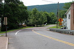
Ridge Road in Jonestown
|
|
 Location within Columbia County |
|
| Location within the state of Pennsylvania | |
| Coordinates: 41°7′43″N 76°18′12″W / 41.12861°N 76.30333°WCoordinates: 41°7′43″N 76°18′12″W / 41.12861°N 76.30333°W | |
| Country | United States |
| State | Pennsylvania |
| County | Columbia |
| Township | Fishing Creek |
| Area | |
| • Total | 0.39 sq mi (1.00 km2) |
| • Land | 0.37 sq mi (0.96 km2) |
| • Water | 0.02 sq mi (0.06 km2) |
| Elevation | 696 ft (212 m) |
| Population (2010) | |
| • Total | 64 |
| • Density | 175/sq mi (67.4/km2) |
| Time zone | Eastern (EST) (UTC-5) |
| • Summer (DST) | EDT (UTC-4) |
| FIPS code | 42-38392 |
| GNIS feature ID | 1178161 |
Jonestown is a census-designated place (CDP) in Columbia County, Pennsylvania, United States. The population was 64 at the 2010 census. It is part of the Bloomsburg–Berwick Micropolitan Statistical Area.
Jonestown was established by Benjamin Jones in 1809, when he built a sawmill in the community, followed by a gristmill in 1811. The gristmill was used until 1968. A path between Wilkes-Barre and Muncy once passed through Jonestown.
Historically, the Susquehanna and Tioga Turnpike passed through Jonestown. As of 1915, there was a hotel in Jonestown.
Jonestown is located in northeastern Columbia County at 41°7′36″N 76°18′9″W / 41.12667°N 76.30250°W (41.126639, -76.302364), at the foot of the north side of Huntington Mountain (also known as Knob Mountain). It is in southeastern Fishing Creek Township, on both sides of Huntington Creek, which runs southwest along the foot of Knob Mountain to join Fishing Creek, which in turn flows to the Susquehanna River.
...
Wikipedia

