Fishing Creek Township, Columbia County, Pennsylvania
| Fishing Creek Township, Pennsylvania |
|
|---|---|
| Township | |

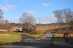
View of Fishing Creek Township in early winter
|
|
 Location of Fishing Creek Township in Columbia County |
|
 Location of Columbia County in Pennsylvania |
|
| Country | United States |
| State | Pennsylvania |
| County | Columbia |
| Settled | 1783 |
| Incorporated | 1789 |
| Area | |
| • Total | 28.7 sq mi (74.4 km2) |
| • Land | 28.4 sq mi (73.6 km2) |
| • Water | 0.3 sq mi (0.8 km2) |
| Population (2010) | |
| • Total | 2,372 |
| • Estimate (2016) | 1,411 |
| • Density | 50/sq mi (19.2/km2) |
| Time zone | Eastern (EST) (UTC-5) |
| • Summer (DST) | EDT (UTC-4) |
| Area code(s) | 570 |
| FIPS code | 42-037-26056 |
| Website | fishingcreektownship |
Fishing Creek Township is a township in Columbia County, Pennsylvania, United States. The population was 1,416 at the 2010 census.
The Josiah Hess Covered Bridge No. 122, Twin Bridges-East Paden Covered Bridge No. 120, and Twin Bridges-West Paden Covered Bridge No. 121 were listed on the National Register of Historic Places in 1979. The Bridge in Fishing Creek Township was listed in 1988.
Fishing Creek Township is in northeastern Columbia County, bordered to the east by Luzerne County. The connected ridges of Huntington Mountain and Knob Mountain form the southern boundary. The township surrounds the borough of Stillwater, a separate municipality. The unincorporated communities of Honeytown, Van Camp, Bendertown, Zaner, Pealertown, Forks, Asbury, and Jonestown are in the township.
According to the United States Census Bureau, the township has a total area of 28.7 square miles (74.4 km2), of which 28.4 square miles (73.6 km2) is land and 0.3 square miles (0.8 km2), or 1.06%, is water. Major streams in the township are Fishing Creek and Huntington Creek, its tributary. Fishing Creek flows south to the Susquehanna River at Bloomsburg.
...
Wikipedia
