Islands of Hawaii

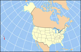
Location of Hawaii within the United States
|
|
| Geography | |
|---|---|
| Location | North Pacific |
| Archipelago | Hawaiian Islands |
| Total islands | Approximately 152 (including 4 of the Midway Atoll) |
| Major islands | Hawaiʻi, Maui, Kahoʻolawe. Lānaʻi, Molokaʻi, Oʻahu, Kauaʻi, Niʻihau |
| Area | 6,423 sq mi (16,640 km2) |
| Length | 1,500 mi (2,400 km) |
| Coastline | 750 mi (1,210 km) |
| Highest point | 13,796 ft (4,205 m) (Mauna Kea) |
| Administration | |
|
United States
|
|
| State | Hawaii (excluding the federally governed Midway Atoll) |
| Demographics | |
| Population | 1,360,301 (2010) |
The following is a list of islands of Hawaii. The state of Hawaii, consisting of the Hawaiian Islands, has the fourth-longest ocean coastline of the 50 states (after Alaska, Florida, and California) at 750 miles (1,210 km). It is the only state that consists entirely of islands with 6,422.62 mi² (16,635 km²) of land. The Hawaiian Island archipelago extends some 1,500 miles (2,400 km) from the southernmost island of Hawaiʻi to the northernmost Kure Atoll. Despite being within the boundaries of Hawaii, Midway Atoll, comprising several smaller islands, is not included as an island of Hawaii, because it is classified as a United States Minor Outlying Islands and is therefore administered by the federal government and not the state.
Hawaii is divided into five counties: Hawaiʻi, Honolulu, Kalawao, Kauaʻi, and Maui. Each island is included in the boundaries and under the administration of one of these counties. Honolulu County, despite being centralized, administers the outlying Northwestern Hawaiian Islands. Kalawao (the smallest county in the United States in terms of land area) and Maui, both occupying the island of Molokaʻi, are the only counties that share the same island. Hawaii is typically recognized by its eight main islands: Hawaiʻi, Maui, Kahoʻolawe, Lānaʻi, Molokaʻi, Oʻahu, Kauaʻi, and Niʻihau.
...
Wikipedia
