Island Eastern Corridor
| Island Eastern Corridor | |
|---|---|
| Part of Route 4 | |

IEC coloured red
|
|
| Route information | |
| Maintained by Highways Department | |
| History: | 1984 (Phase I) 1985 (Phase II) 1989 (Phase III) |
| Major junctions | |
| East end: | Chai Wan |
| West end: | Causeway Bay |
| Location | |
| Districts: | Eastern, Wan Chai |
| Highway system | |
| Hong Kong Strategic Route and Exit Number System | |
| Island Eastern Corridor | |||||||||||

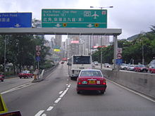
The west end of Island Eastern Corridor at Causeway Bay
|
|||||||||||
| Traditional Chinese | 東區走廊 | ||||||||||
|---|---|---|---|---|---|---|---|---|---|---|---|
| Simplified Chinese | 东区走廊 | ||||||||||
|
|||||||||||
| Transcriptions | |
|---|---|
| Standard Mandarin | |
| Hanyu Pinyin | Dōng Qū Zǒuláng |
| Yue: Cantonese | |
| Yale Romanization | dung1 keui1 jau2 long4 |
Island Eastern Corridor (IEC) is an expressway built along the northeastern shore of Hong Kong Island in Hong Kong. It starts from Causeway Bay in the west and ends in Chai Wan in the east. It is part of Route 4. The section between Causeway Bay and Quarry Bay consists mainly of viaducts built along Victoria Harbour.
After World War II, the Eastern District of Hong Kong Island developed rapidly. As a result, the major thoroughfare in the area, King's Road, became very congested.
To relieve the congestion problem, the idea of constructing the corridor was brought out in 1968. However, commencement of construction did not begin until 8 April 1981, 20 May 1982 and 5 August 1986. The corridor was opened in three phases: Causeway Bay to Tai Koo Shing on 8 June 1984; Tai Koo Shing to Shau Kei Wan on 26 July 1985; and Shau Kei Wan to Chai Wan on 12 October 1989.
Work has been done to the expressway several times over its life, including the bridge diversions at Quarry Bay, completed in 2003, where Route 4 joins with Route 2. There is also a proposed extension of the Corridor into the hills of Chai Wan and Siu Sai Wan.
...
Wikipedia

