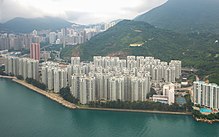
Chai Wan
| Chai Wan | |||||||||||

A view of Chai Wan, Siu Sai Wan and the Cargo Handling Basin
|
|||||||||||
| Traditional Chinese | 柴灣 | ||||||||||
|---|---|---|---|---|---|---|---|---|---|---|---|
| Simplified Chinese | 柴湾 | ||||||||||
| Cantonese Yale | Chàaihwāan | ||||||||||
| Hanyu Pinyin | Chaiwan | ||||||||||
| Literal meaning | firewood bay | ||||||||||
|
|||||||||||
| Transcriptions | |
|---|---|
| Standard Mandarin | |
| Hanyu Pinyin | Chaiwan |
| Yue: Cantonese | |
| Yale Romanization | Chàaihwāan |
| Heng Fa Chuen | |||||||||||||

A bird's eye view of Heng Fa Chuen
|
|||||||||||||
| Traditional Chinese | 杏花邨 | ||||||||||||
|---|---|---|---|---|---|---|---|---|---|---|---|---|---|
| Simplified Chinese | 杏花邨 | ||||||||||||
| Cantonese Yale | Hahngfāchyùn | ||||||||||||
| Literal meaning | Almond Flower Village | ||||||||||||
|
|||||||||||||
| Transcriptions | |
|---|---|
| Standard Mandarin | |
| Hanyu Pinyin | Xìnghuācūn |
| Yue: Cantonese | |
| Yale Romanization | Hahngfāchyùn |
| Jyutping | Hang6 Faa1 Cyun1 |
Chai Wan (/ˌtʃaɪ ˈwɑːn/; Chinese: 柴灣), formerly known as Sai Wan (西灣), lies at the east end of the urban area of Hong Kong Island next to Shau Kei Wan. The area is administratively part of the Eastern District, and is a mosaic of industrial and residential areas. The population was 186,505 in 2001.
Chai Wan is built on land reclaimed from the bay and extends west from Lei Yue Mun in Heng Fa Chuen (see below) and east to Siu Sai Wan. Mount Collinson and Pottinger Peak on the south and Mount Parker on the west, restrict further development. Shek O Country Park is at the south of Chai Wan.
Chai Wan was formerly known as Sai Wan (西灣). At the beginning of the 18th century, the area consisted of six villages: Dai Ping Village, Law Uk, Luk Uk, Nam Uk, Sai Village, Sing Uk.
In 1845, the British military built a fort and a barracks in Siu Sai Wan. In December 1941 the Japanese invasion of the island resulted in the Battle of Hong Kong, with approximately 20 gunners executed at the Sai Wan Battery despite having surrendered. After the fort was closed in the 1980's Sai Sau Wan become an area for new population.
In 1929, the Boy Scouts Association, Hong Kong Branch purchased land for the Chai Wan Campsite where Chai Wan Park is now situated. The land returned to Hong Kong Government for development in the early 1970s.
...
Wikipedia
