Iron County, Michigan
| Iron County, Michigan | |
|---|---|

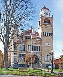
Iron County Courthouse
|
|
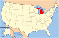
 Location in the U.S. state of Michigan |
|
 Michigan's location in the U.S. |
|
| Founded | April 3, 1885 |
| Named for | Iron ore |
| Seat | Crystal Falls |
| Largest city | Iron River |
| Area | |
| • Total | 1,211 sq mi (3,136 km2) |
| • Land | 1,166 sq mi (3,020 km2) |
| • Water | 45 sq mi (117 km2), 3.7% |
| Population | |
| • (2010) | 11,817 |
| • Density | 10/sq mi (4/km²) |
| Congressional district | 1st |
| Time zone | Central: UTC-6/-5 |
| Website | ironmi |
Iron County is a county in the Upper Peninsula of the U.S. state of Michigan. As of the 2010 census, the population was 11,817. The county seat is Crystal Falls.
Iron County was organized in 1885 from territory taken from Marquette and Menominee counties. In 1890, the county's population was 4,432. It was named for the valuable iron ore found within its borders.
According to the U.S. Census Bureau, the county has an area of 1,211 square miles (3,140 km2), of which 1,166 square miles (3,020 km2) is land and 45 square miles (120 km2) (3.7%) is water.
The 2010 United States Census indicates Iron County had a population of 11,817. This is a decrease of 1,321 people from the 2000 United States Census. This is a -10.1% change in population. In 2010 there were 5,577 households and 3,284 families residing in the county. The population density was 10 people per square mile (4/km²). There were 9,197 housing units at an average density of 8 per square mile (3/km²). 97.1% of the population were White, 0.9% Native American, 0.3% Asian, 0.1% Black or African American, 0.2% of some other race and 1.4% of two or more races. 1.4% were Hispanic or Latino (of any race). 14.3% were of German, 11.5% Finnish, 11.3% Italian, 8.6% French, French Canadian or Cajun, 8.0% Swedish, 6.5% English, 5.8% American and 5.4% Irish ancestry.
...
Wikipedia
