Irinjalakuda
|
Irinjalakuda ഇരിങ്ങാലക്കുട |
|
|---|---|
| Municipality and town | |

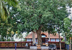
Payammal Shathrugna Temple
|
|
| Nickname(s): Varadanangalude Nadu (വരദാനങ്ങളുടെ നാട്) | |
| Location in Kerala, India | |
| Coordinates: 10°20′N 76°14′E / 10.33°N 76.23°ECoordinates: 10°20′N 76°14′E / 10.33°N 76.23°E | |
| Country |
|
| State | Kerala |
| District | Thrissur |
| Government | |
| • Type | Municipality |
| • Body | Irinjalakuda Municipal Council |
| Area | |
| • Total | 33.57 km2 (12.96 sq mi) |
| Elevation | 39 m (128 ft) |
| Population (2011) | |
| • Total | 51,585 |
| • Density | 1,500/km2 (4,000/sq mi) |
| Languages | |
| • Official | Malayalam, English |
| Time zone | IST (UTC+5:30) |
| Telephone code | 0480 |
| Vehicle registration | KL-45 |
Irinjalakuda is a Municipal town in Thrissur district, Kerala, India. Irinjalakuda is the headquarters of Mukundapuram Taluk.
According to Hindu mythology, Irinjalakuda was created by sage Parasurama. According to Keralolpatthi, out of the 64 gramas (villages) established in Kerala( Out of these 32 Malayala Gramas & one Thulu grama viz.Manjeswaram are in the present Kerala and 31 Thulu Gramas in the coastal Karnataka.), Irinjalakuda was the head of some of them. Irinjalakuda was one of the most prominent among these Gramas(village societies).Boundaries of this grama extends up to Potta in the east and Kakkathuruthi in the west. Like the other Gramas this 'Grama' also followed Sankara Smruthi(a modified form of the 'Chathurvarnia' system of society with some Kerala model variations which lay upon caste system based on the 'Manusmruthi').
The name Irinjalakuda has been derived from "Iru" and "Chaal", meaning two streams. According to another legend, the origin of the name Irinjalakuda came from 'Irinjalikoodal'. 'Koodal' simply means merge, merging of two rivers.So it shows that Irinjalakuda may have gradually developed, from 'Irinjalikoodal', that derived from 'Inangikoodal', means merge. At present there is no river in Irinjalakuda, only the myth of river.
In 1762 Maharaja of Kochi formed Mukundapuram taluk by adding Mapranam Nadu and parts of Nandilathu Nadu to Mukundapuram Nadu(Muriya Nadu).In the last decade of the 18th Century the last Naduvazhi Nambiar of Mukundapuram Nadu(Murija Nadu) died and Sakthan Thampuran confiscated all the powers and properties Mukundapuram Nambiar and Mapranam Nambiar.Sakthan Thampuran divided old Mukundapuram Taluk into six Proverties viz.1) Thazhekkad 2) Areepalam, 3)Mukundapuram(Nadavarambu) 4) Mapranam 5)Palathungal(Nellayi)6)Pudukkad for administrative and revenue purposes .Five more proverties were added to Mukundapuram Taluk afterwards.They are Kodassery(Chalakudy), Thirumukkulam(Kuzhur)), Koratty(Adur),Pathinettarayalam (Edavilangu) and Malayattur.When new Chalakudy Taluk was formed in 2013 by bifrurcating Mukundapuram taluk it lost more than 50% of its territory.
Another legend suggests that the origin of the name Irinjalakuda were heard, "Irunnu Salayil Koodai", and "Virinja Alu Kuda". There is a huge Banyan tree still standing in the centre of the Irinjalakuda spreading the branches to the sky like an umbrella. Tippu Sulthan's Army was based at Thazhekkad Proverty of Mukundapuram Taluk on 24 December 1789 to attack the Nedumkotta which is situated in the middle of Kochi Kingdom and was known as Travancore lines and attacked KonurKottavathil in January 1790. Before the arrival of Tipu Sulthan to Mukundapuram Taluk in December 1789 the headquarters of Padruado Archbishops of Cranganore(Kodungallur)of Syro-Indian Christians(Nazranis) was at Pookkatt(Aripalam) .(See Varthamanapusthakam of Paremakkal Thoma Kathanar,Gobernador and ArchaDeacon of late Eighteenth century). Sakthan Thampuran brought four Christian families for improving commerce and trade to the place known as ‘Chanthappura’. When they struck gold in this field, more of this community migrated from Kombara chantha and settled in the area and now it became one of the strongholds of this community. Besides Hindu and Christian communities this area consists of Muslims.
...
Wikipedia


