Interstate 97
| Interstate 97 | ||||
|---|---|---|---|---|

I-97 highlighted in red
|
||||
| Route information | ||||
| Maintained by MDSHA | ||||
| Length: | 17.62 mi (28.36 km) | |||
| Existed: | 1987 – present | |||
| Major junctions | ||||
| South end: |
|
|||
|
||||
| North end: |
|
|||
| Location | ||||
| Counties: | Anne Arundel | |||
| Highway system | ||||
|
||||
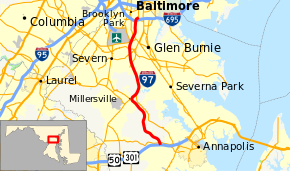
Interstate 97 (I-97) is a part of the Interstate Highway System that runs entirely within Anne Arundel County, Maryland. The intrastate Interstate runs 17.62 miles (28.36 km) from U.S. Route 50 (US 50) and US 301 in Parole near Annapolis north to I-695 and I-895 in Brooklyn Park near Baltimore. The Interstate is the primary highway between Baltimore and Annapolis. I‑97 connects Annapolis with Baltimore–Washington International Airport and links the northern Anne Arundel County communities of Crownsville, Millersville, Severna Park, Glen Burnie, and Ferndale. It is the shortest primary Interstate Highway.
I-97 was constructed along the corridor of Maryland Route 3 (MD 3) between Millersville and Ferndale and MD 178 between Parole and Millersville. From Millersville to south of Glen Burnie, the Interstate closely follows the former course of MD 3, which was built in the late 1910s and early 1920s and expanded to a divided highway in the late 1950s. North of there, the highway follows the Glen Burnie Bypass, a freeway built in the mid-1950s. The segment of I-97 from Millersville to Crownsville originated as a two-lane portion of MD 32 in the early 1970s. The Interstate was introduced in 1979 after the state of Maryland successfully obtained Interstate mileage for a Baltimore–Annapolis freeway from the federal government. The state decided to build the highway along I-97's current corridor rather than along the MD 2 corridor, which has partial freeway access via MD 10.
...
Wikipedia

