Brooklyn Park, Maryland
| Brooklyn Park, Maryland | |
|---|---|
| Census-designated place | |

View east along Maryland State Route 171 (Church Street) at Maryland State Route 2 (Governor Ritchie Highway) in Brooklyn Park.
|
|
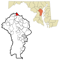
 Location of Brooklyn Park, Maryland |
|
| Coordinates: 39°13′29″N 76°36′46″W / 39.22472°N 76.61278°WCoordinates: 39°13′29″N 76°36′46″W / 39.22472°N 76.61278°W | |
| Country | |
| State |
|
| County |
|
| Area | |
| • Total | 4.3 sq mi (11.1 km2) |
| • Land | 4.2 sq mi (10.9 km2) |
| • Water | 0.08 sq mi (0.2 km2) |
| Elevation | 112 ft (34 m) |
| Population (2010) | |
| • Total | 14,373 |
| • Density | 3,422/sq mi (1,321.4/km2) |
| Time zone | Eastern (EST) (UTC-5) |
| • Summer (DST) | EDT (UTC-4) |
| FIPS code | 24-10475 |
| GNIS feature ID | 0589827 |
Brooklyn Park is a census-designated place (CDP) in Anne Arundel County, Maryland, United States. The population was 14,373 at the 2010 census.
Brooklyn Park is located at 39°13′29″N 76°36′46″W / 39.22472°N 76.61278°W (39.224857, -76.612655) on the northern edge of Anne Arundel County and borders the city of Baltimore along its southern boundary of 1919. The CDP is bordered as well by Interstate 695 (the Baltimore Beltway) to the south, by Maryland Route 648 (Old Annapolis Road) to the west, and by the Patapsco River, which forms the Anne Arundel County/Baltimore County boundary, to the northwest.
According to the United States Census Bureau, the CDP has a total area of 4.3 square miles (11.1 km2), of which 4.2 square miles (10.9 km2) is land and 0.077 square miles (0.2 km2), or 1.65%, is water, consisting largely of the Patapsco River and associated wetlands.
Within the Baltimore city limits, adjacent to the CDP, are the older neighborhoods of Brooklyn (founded 1853), Curtis Bay (development proposed in 1874, buildings began in 1889), and several smaller communities that are now defunct: Fairfield, Masonville, Wagner's Point (also known as East Brooklyn), Arundel Cove, and Hawkins Point.
...
Wikipedia
