Ferndale, Maryland
| Ferndale, Maryland | |
|---|---|
| Census-designated place | |

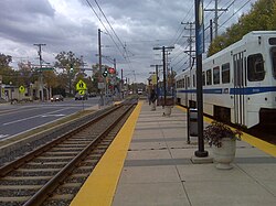
Ferndale Station platform.
|
|
|
Nickname(s): = Mayor Scottie Arcoraci |
|
 Location of Ferndale, Maryland |
|
| Coordinates: 39°11′17″N 76°38′9″W / 39.18806°N 76.63583°WCoordinates: 39°11′17″N 76°38′9″W / 39.18806°N 76.63583°W | |
| Country | |
| State |
|
| County |
|
| Area | |
| • Total | 4.0 sq mi (10.3 km2) |
| • Land | 4.0 sq mi (10.3 km2) |
| • Water | 0.0 sq mi (0.0 km2) |
| Elevation | 79 ft (24 m) |
| Population (2010) | |
| • Total | 16,746 |
| • Density | 4,212/sq mi (1,626.4/km2) |
| Time zone | Eastern (EST) (UTC-5) |
| • Summer (DST) | EDT (UTC-4) |
| FIPS code | 24-28075 |
| GNIS feature ID | 0590203 |
Nickname(s): =
Ferndale is a census-designated place (CDP) in Anne Arundel County, Maryland, in the United States. As of the 2010 census, the population was 16,746. Many of which frequent the Ferndale Tavern which is a local "watering hole" located adjacent to the Light Rail stop.
Ferndale is located at 39°11′17″N 76°38′9″W / 39.18806°N 76.63583°W (39.188065, -76.635810) in northern Anne Arundel County, 5 miles (8 km) south of the Baltimore city line. The Ferndale CDP is bounded by Interstate 695 (the Baltimore Beltway) and Cabin Branch (a stream) to the north, by Maryland Route 162 (Aviation Boulevard) to the west, by Maryland Route 176 (Dorsey Road) and 8th Avenue to the south, and by Maryland Route 2 (Governor Ritchie Highway) to the east. Neighboring communities are Linthicum to the northwest, Brooklyn Park to the northeast, and Glen Burnie to the east and south. Baltimore–Washington International Thurgood Marshall Airport is to the west across Aviation Boulevard.
...
Wikipedia
