Maryland Route 3
| Maryland Route 3 | ||||
|---|---|---|---|---|
| Robert Crain Highway | ||||

Maryland Route 3 highlighted in red
|
||||
| Route information | ||||
| Maintained by MDSHA | ||||
| Length: | 9.56 mi (15.39 km) | |||
| Existed: | 1927 – present | |||
| Major junctions | ||||
| South end: |
|
|||
|
|
||||
| North end: |
|
|||
| Location | ||||
| Counties: | Prince George's, Anne Arundel | |||
| Highway system | ||||
|
||||
| Maryland Route 3 Business | |
|---|---|
| Location: | Glen Burnie |
| Length: | 5.08 mi (8.18 km) |
|
Maryland Route 3 Truck |
|
|---|---|
| Location: | Baltimore |
![]() MD 450 near Bowie
MD 450 near Bowie![]() MD 424 in Crofton
MD 424 in Crofton
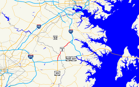
Maryland Route 3 (MD 3), part of the Robert Crain Highway, is the designation given to the former alignment of U.S. Route 301 from Bowie, Maryland, USA, to Baltimore. It is named for Robert Crain of Baltimore. It is unique in Maryland in that it has a business route and a truck route which do not connect to their parent; however, the business route is also a part of the Robert Crain Highway. MD 3's current orientation is vestigial from the construction of Maryland's freeway system.
MD 3 begins within the modified cloverleaf interchange of US 50 and unsigned I-595 (John Hanson Highway) and US 301 (Robert Crain Highway) in Bowie, Prince George's County. Within the interchange, US 301 heads south on Crain Highway and east along US 50; meanwhile, MD 3 heads north on Crain Highway, a four-lane divided highway. A short distance after beginning, the route comes to a partial cloverleaf interchange with Belair Drive, containing continuing connections from the US 50/US 301 interchange. Past here, the road runs north through wooded residential areas before the median widens and it bends to the north-northeast, continuing through forested areas with a few businesses. MD 3 continues northeast and the median narrows, with the road widening to eight lanes as it comes to an intersection with MD 450. At this point, MD 450 heads northeast for a concurrency with MD 3 along a six-lane divided highway, running through wooded areas and coming to a bridge over the Patuxent River.
...
Wikipedia

