Interstate 95 in Baltimore, Maryland
| Interstate 95 | ||||
|---|---|---|---|---|
 |
||||
| Route information | ||||
| Maintained by MDSHA | ||||
| Length: | 109.01 mi (175.43 km) | |||
| Existed: | 1963 – present | |||
| Tourist routes: |
|
|||
| Major junctions | ||||
| South end: |
|
|||
| North end: |
|
|||
| Location | ||||
| Counties: | Prince George's, Howard, Baltimore, City of Baltimore, Harford, Cecil | |||
| Highway system | ||||
|
||||
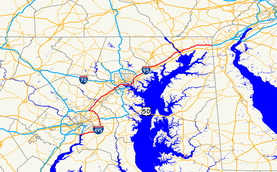
Interstate 95 in Maryland is a major highway that runs 109.01 miles (175.43 km) diagonally from northeast to southwest, from Maryland's border with Delaware, to the Woodrow Wilson Bridge, briefly entering the District of Columbia before reaching Virginia. The route is one of the most heavily traveled Interstate Highways in Maryland, especially between Baltimore and Washington, D.C., despite alternate routes along the corridor, such as the Baltimore-Washington Parkway, U.S. 1, and U.S. Route 29. Portions of the highway are tolled.
Between the Delaware state line and the Baltimore City line, I-95 is known as the John F. Kennedy Memorial Highway.
Interstate 95 enters the state of Maryland concurrent with Interstate 495, the Capital Beltway. From Alexandria, Virginia, the roadways, five lanes in either direction, travel together over the Woodrow Wilson Memorial Bridge, briefly cross the southern tip of the District of Columbia (over water), and touch down in Prince George's County west of Forest Heights. I-95/I-495 immediately encounter the southern terminus of Interstate 295, known as the Anacostia Freeway, a route that serves downtown Washington, D.C. and connects to the originally planned alignment of I-95 through D.C., Interstate 395. Just beyond I-295 the two routes interchange with MD 210, a major north–south route into southern D.C.
...
Wikipedia

