Interstate 77 in Ohio
| Interstate 77 | ||||
|---|---|---|---|---|

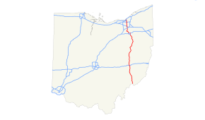
I-77 highlighted in red
|
||||
| Route information | ||||
| Maintained by ODOT | ||||
| Length: | 163.03 mi (262.37 km) | |||
| Major junctions | ||||
| South end: |
|
|||
|
|
||||
| North end: |
|
|||
| Location | ||||
| Counties: | Washington, Noble, Guernsey, Tuscarawas, Stark, Summit, Cuyahoga | |||
| Highway system | ||||
|
||||
| Interstate I-77 Alternate | |
|---|---|
| Location: | Summit County |
Interstate 77 (I-77) is an Interstate Highway in the eastern United States. It traverses diverse terrain, from the mountainous state of West Virginia to the rolling farmlands of North Carolina and Ohio. It largely supplants the old U.S. Route 21 between Cleveland, Ohio, and Columbia, South Carolina, as an important north–south corridor through the middle Appalachians. The southern terminus of Interstate 77 is in Columbia at the junction with Interstate 26. The northern terminus is in Cleveland at the junction with Interstate 90.
Entering from West Virginia at Marietta via the Marietta–Williamstown Interstate Bridge, Interstate 77 passes through rolling Appalachian terrain.
The interchange with I-70 at Cambridge was noted on the cover of the 1969 Ohio Department of Highways official highway map as being the "World's Largest Interchange", covering over 300 acres (1.2 km2) of land.
Other major Interstate Highways I-77 connects with in Ohio are I-76, I-80 (Ohio Turnpike), and I-90. The interchange with the Ohio Turnpike was completed December 3, 2001, providing direct access; previously, traffic had to exit at Ohio State Route 21 to get to the Turnpike.
...
Wikipedia

