Interstate 30 Business (Benton, Arkansas)
| Interstate 30 | |
|---|---|
 |
|
| Route information | |
| Length: | 366.76 mi (590.24 km) |
| Major junctions | |
| West end: |
|
|
|
| East end: |
|
| Location | |
| States: | Texas, Arkansas |
| Counties: |
TX: Parker, Tarrant, Dallas, Rockwall, Hunt, Hopkins, Franklin, Titus, Morris, Bowie AR: Miller, Hempstead, Nevada, Clark, Hot Spring, Saline, Pulaski |
| Highway system | |
|
|
|
| Interstate 30 Business | |
|---|---|
| Location: | Benton, Arkansas |
| Length: | 3.8 mi (6.1 km) |
| Existed: | c. 1960–c. 1975 |
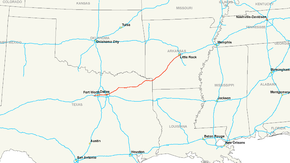
Interstate 30 (I-30) is an Interstate Highway in the southern United States in Texas and Arkansas. I-30 runs from I-20 west of Fort Worth, Texas, northeast via Dallas, and Texarkana, Texas, to I-40 in North Little Rock, Arkansas. The route parallels U.S. Route 67 (US 67) except for the portion west of downtown Dallas (which was once part of I-20). I-30 intersects with only two of the 10 major north–south Interstates (I-35W, I-35E and I-45) and also with the major Interstate routes I-20, and I-40. I-30 is known as the Tom Landry Freeway between I-35W and I-35E, within the core of the Dallas–Fort Worth metroplex.
I-30 is the shortest two-digit Interstate ending in zero in the Interstate system. The Interstates ending in 0 are generally the longest east–west Interstates. It is also the second shortest major Interstate (ending in 0 or 5), behind Interstate 45. The largest areas that I-30 goes through include the Dallas/Fort Worth Metroplex, the Texarkana metropolitan area, and the Little Rock metropolitan area.
...
Wikipedia

