Benton, Arkansas
| Benton, Arkansas | |
|---|---|
| City | |

Saline County Courthouse, located in the heart of downtown Benton.
|
|
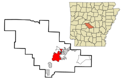
 Location in Saline County and the state of Arkansas |
|
| Location in the United States | |
| Coordinates: 34°34′15″N 92°34′37″W / 34.57083°N 92.57694°WCoordinates: 34°34′15″N 92°34′37″W / 34.57083°N 92.57694°W | |
| Country |
|
| State |
|
| County | Saline |
| Government | |
| • Type | Mayor-Council |
| • Mayor | David Mattingly |
| • City Council | Frank Baptist Kerry Murphy Charles Cunningham Joe Lee Richards Bill Donnor Jerry Ponder Brad Moore James Herzfeld Steve Lee Lori Terrell |
| Area | |
| • Total | 47.8 km2 (18.4 sq mi) |
| • Land | 46.5 km2 (17.9 sq mi) |
| • Water | 1.3 km2 (0.5 sq mi) |
| Elevation | 124 m (407 ft) |
| Population (2015) | |
| • Total | 34,177 |
| • Density | 458.3/km2 (1,190.5/sq mi) |
| Time zone | Central (CST) (UTC-6) |
| • Summer (DST) | CDT (UTC-5) |
| ZIP code | 72015, 72018-19, 72158 |
| Area code(s) | 501 |
| FIPS code | 05-05290 |
| GNIS feature ID | 0046394 |
| Website | Official website |
Benton is a city in and the county seat of Saline County, Arkansas, United States and a suburb of Little Rock. It was established in 1837. According to a 2006 Special Census conducted at the request of the city government, the population of the city is 27,717, ranking it as the state's 16th largest city, behind Texarkana. However, in the 2010 census, the city population increased to 30,681, making it the 12th largest city in the state of Arkansas. In 2014, the population increased again to 33,625 It is part of the Little Rock–North Little Rock–Conway Metropolitan Statistical Area. The city of Benton, first settled in 1833 and named after Missouri Senator Thomas Hart Benton, was formally chartered in 1836 when Arkansas became a state.
According to the United States Census Bureau, the city has a total area of 18.4 square miles (48 km2), of which 17.9 square miles (46 km2) is land and 0.5 square miles (1.3 km2) (2.71%) is water.
As of the census of 2000, there were 21,906 people, 8,713 households, and 6,186 families residing in the city. The population density was 1,221.2 people per square mile (471.5/km²). There were 9,315 housing units at an average density of 519.3 per square mile (200.5/km²). The racial makeup of the city was 92.81% White, 4.46% Black or African American, 0.39% Native American, 0.56% Asian, 0.05% Pacific Islander, 0.75% from other races, and 1.19% from two or more races. 1.90% of the population were Hispanic or Latino of any race.
...
Wikipedia

