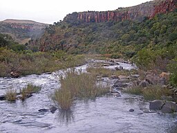
Incomati
| Komati River | |
| Komatirivier | |
| River | |
| Name origin: From the Swazi language word for "cow", meaning hippos | |
| Countries | South Africa, Swaziland, Mozambique |
|---|---|
| Source | Steenkampsberg |
| - location | Near Ermelo, Mpumalanga |
| - elevation | 1,800 m (5,906 ft) |
| Mouth | Indian Ocean |
| - location | Maputo Bay |
| - coordinates | 25°48′57.46″S 32°43′38.89″E / 25.8159611°S 32.7274694°ECoordinates: 25°48′57.46″S 32°43′38.89″E / 25.8159611°S 32.7274694°E |
| Length | 480 km (298 mi) |
| Basin | 50,000 km2 (19,305 sq mi) |
| Discharge | |
| - average | 111 m3/s (3,920 cu ft/s) |
The Komati River (also called Incomati River) is a river in South Africa, Swaziland and Mozambique. It is 480 kilometres (298 mi) long, with a drainage basin 50,000 square kilometres (19,300 sq mi) in size. Its mean annual discharge is 111 m3/s (3,920 cfs) at its mouth. The name Komati is derived from inkomati (siSwati), meaning "cow", as its perennial nature is compared to a cow that always has milk.
The river originates west of Carolina, rising at an elevation of about 1,800 m (5,906 ft) near Breyten in the Ermelo district of the Mpumalanga province. It flows in a general northeasterly direction and reaches the Indian Ocean at Maputo Bay, after a course of some 480 km (298 mi). The Komati Gorge is situated in the upper reaches of the Komati River and is the habitat of some endangered species such as the southern bald ibis. In 2001 the 115 m high wall of the Maguga Dam was completed south of Piggs Peak, Swaziland, 26°4′51.57″S 31°15′25.84″E / 26.0809917°S 31.2571778°E.
...
Wikipedia


