Inari, Finland
|
Inari Inari – Aanaar – Anár – Aanar |
||
|---|---|---|
| Municipality | ||
| Inarin kunta | ||

Lapland Shop in Inari in 1975
|
||
|
||
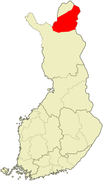
 Location of Inari in Finland |
||
| Coordinates: 68°54′18″N 027°01′49″E / 68.90500°N 27.03028°ECoordinates: 68°54′18″N 027°01′49″E / 68.90500°N 27.03028°E | ||
| Country |
|
|
| Region | Lapland | |
| Sub-region | Northern Lapland | |
| Charter | 1876 | |
| Government | ||
| • Municipal manager | Reijo Timperi | |
| Area (2016-01-01) | ||
| • Total | 15,055.10 km2 (5,812.81 sq mi) | |
| • Land | 15,052.36 km2 (5,811.75 sq mi) | |
| • Water | 2,281.41 km2 (880.86 sq mi) | |
| Area rank | Largest in Finland | |
| Population (2016-03-31) | ||
| • Total | 6,777 | |
| • Rank | 143rd largest in Finland | |
| • Density | 0.45/km2 (1.2/sq mi) | |
| Population by native language | ||
| • Finnish | 92.7% (official) | |
| • Swedish | 0.2% | |
| • Sami | 5.9% (official) | |
| • Others | 1.1% | |
| Population by age | ||
| • 0 to 14 | 13.8% | |
| • 15 to 64 | 68.8% | |
| • 65 or older | 17.4% | |
| Time zone | EET (UTC+2) | |
| • Summer (DST) | EEST (UTC+3) | |
| Municipal tax rate | 19% | |
| Website | www.inari.fi | |
Inari (Inari Sami: Aanaar, Northern Sami: Anár, Skolt Sami: Aanar, Swedish: Enare) is Finland's largest, most sparsely populated municipality, with four official languages, more than any other in the country. Its major sources of income are the lumber (timber) industry, nature maintenance and tourism. With the Siida museum in the village of Inari, it is a center of Sami culture. The airport in Ivalo and the country's key north-south European Route E75 (Finland's National Road 4) bring summer and winter vacationers seeking resorts with access to a well-preserved, uncrowded natural environment.
The municipality of Inari has a population of 6,777 (31 March 2016). The population density is 0.45 inhabitants per square kilometre (1.2/sq mi).
Its two largest villages are Ivalo and Inari. Other villages are Törmänen, Keväjärvi, Koppelo, Sevettijärvi–Näätämö, Saariselkä, Nellim, Angeli, Kaamanen, Kuttura, Lisma, Partakko, and Riutula.
...
Wikipedia

