Hurricane Greta (1956)
| Category 2 hurricane (SSHWS/NWS) | |

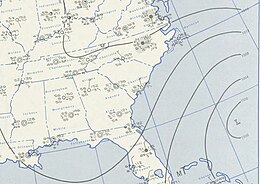
November 2, 1956 weather map, featuring the storm
|
|
| Formed | October 30, 1956 |
|---|---|
| Dissipated | November 6, 1956 |
| Highest winds |
1-minute sustained: 100 mph (155 km/h) |
| Lowest pressure | 970 mbar (hPa); 28.64 inHg |
| Fatalities | 1 direct |
| Damage | $3.6 million (1956 USD) |
| Areas affected | Jamaica, Hispaniola, Cuba, The Bahamas, Southeast United States, Turks and Caicos Islands, Puerto Rico, Lesser Antilles |
| Part of the 1956 Atlantic hurricane season | |
Hurricane Greta was an extremely large late-season Atlantic hurricane in the 1956 Atlantic hurricane season. Originating from a tropical depression near Jamaica on October 30, the system initially featured non-tropical characteristics as it tracked northward. By November 2, the system began producing gale-force winds around the low pressure area; however, winds near the center of circulation were calm. By November 3, the system intensified into a tropical storm and was named Greta. Steadily strengthening, Greta attained hurricane intensity on November 4, eventually reaching a peak intensity with 100 mph (155 km/h) winds. Shortly after, Greta began to gradually weaken as it tracked over cooler waters. The storm eventually became extratropical on November 7 over the central Atlantic. Although Greta did not directly impact land as a tropical storm or hurricane, it generated large swells that impacted numerous areas. One person was killed in Puerto Rico and coastal damages from the waves amounted to roughly $3.6 million (1956 USD).
Hurricane Greta originated out of a tropical disturbance in the Intertropical Convergence Zone near Jamaica on October 30, 1956. A Navy reconnaissance plane recorded sustained winds of 35 mph (55 km/h) and found an area of low pressure. Around this time, the system was classified as a tropical depression. Although a ship near the system discovered a cold-core circulation—a feature of non-tropical cyclones—it was classified as tropical. By October 31, the depression passed near the western edge of Haiti and later crossed the eastern tip of Cuba before entering the Atlantic Ocean. By the afternoon of November 1, the depression had moved through the central Bahamas and turned towards the northeast.
By this time, the central pressure of the depression had decreased to 998 mbar (hPa; 29.47 inHg) and gale-force winds were recorded over a large area, and the system was upgraded to a tropical storm that morning. The system was compared to that of a Kona low, a large-scale subtropical cyclone that forms near Hawaii. Early on November 2, the storm turned northwest in response to an area of high pressure over the central Atlantic. Later that day, the first scientific mission into a hurricane with two planes took place when two research aircraft flew into Greta. During the day, an Air Force B-50 aircraft and NHRP B-47 high altitude jet flew into the storm. The storm executed a counter-clockwise loop, ending on November 3, during which time numerous reconnaissance missions were flown into the system. By this time, the storm had also begun a southeastward track.
...
Wikipedia
