Hurricane Flora
| Category 4 major hurricane (SSHWS/NWS) | |

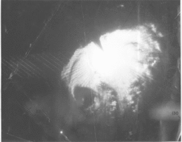
Radar image of Hurricane Flora
|
|
| Formed | September 26, 1963 |
|---|---|
| Dissipated | October 12, 1963 |
| Highest winds |
1-minute sustained: 145 mph (230 km/h) |
| Lowest pressure | 940 mbar (hPa); 27.76 inHg |
| Fatalities | 7,186 - 8,000 [1] |
| Damage | $528 million (1963 USD) |
| Areas affected | Northern South America, Lesser Antilles, Trinidad and Tobago, Leeward Antilles, Puerto Rico, Hispaniola, Jamaica, Cuba, Bahamas, Turks and Caicos Islands, Bermuda, Atlantic Canada |
| Part of the 1963 Atlantic hurricane season | |
Hurricane Flora is among the deadliest Atlantic hurricanes in recorded history, with a death total of over 7,000. The seventh tropical storm and sixth hurricane of the 1963 Atlantic hurricane season, Flora developed from a disturbance in the Intertropical Convergence Zone on September 26 while located 755 miles (1,215 km) southwest of the Cape Verde islands. After remaining a weak depression for several days, it rapidly organized on September 29 to attain tropical storm status. Flora continued to quickly strengthen to reach Category 3 hurricane status before moving through the Windward Islands and passing over Tobago, and it reached maximum sustained winds of 145 miles per hour (233 km/h) in the Caribbean.
The storm struck southwestern Haiti near peak intensity, turned to the west, and drifted over Cuba for four days before turning to the northeast. Flora passed over the Bahamas and accelerated northeastward, becoming an extratropical cyclone on October 12. Due to its slow movement across Cuba, Flora is the wettest known tropical cyclone for Cuba, Haiti, and the Dominican Republic. The significant casualties caused by Flora were the most for a tropical cyclone in the Atlantic Basin since the 1900 Galveston Hurricane.
A disturbance in the Intertropical Convergence Zone organized into a tropical depression on September 26 while located about 755 miles (1,215 km) southwest of the island of Fogo in the Cape Verde Islands. Upon forming, the depression had a poorly organized circulation with banding features to its north and east. The depression moved west-northwestward, and the system failed to organize significantly by a day after developing. On September 27, the banding features dissipated, though the area of convection around the center increased. Satellite imagery was unavailable until September 30, during which there were not sufficient ship reports to indicate the presence of a low-level circulation. The depression continued west-northwestward, and it is estimated it intensified into Tropical Storm Flora on September 29 while located about 560 miles (900 km) east-southeast of Trinidad, or about 350 miles (560 km) north of Cayenne, French Guiana. Operationally, advisories were not initiated until a day later.
...
Wikipedia
