Huittinen
|
Huittinen Vittis |
||
|---|---|---|
| Town | ||
| Huittisten kaupunki | ||

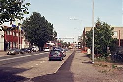
A view from Lauttakylä, central Huittinen
|
||
|
||
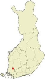
 Location of Huittinen in Finland |
||
| Coordinates: 61°10.5′N 022°42′E / 61.1750°N 22.700°ECoordinates: 61°10.5′N 022°42′E / 61.1750°N 22.700°E | ||
| Country |
|
|
| Region | Satakunta | |
| Sub-region | Pori sub-region | |
| Charter | 1865 | |
| Market town | 1972 | |
| Town privileges | 1977 | |
| Government | ||
| • Town manager | Jyrki Peltomaa | |
| Area (2016-01-01) | ||
| • Total | 532.63 km2 (205.65 sq mi) | |
| • Land | 532.62 km2 (205.65 sq mi) | |
| • Water | 6.97 km2 (2.69 sq mi) | |
| Area rank | 163rd largest in Finland | |
| Population (2016-03-31) | ||
| • Total | 10,465 | |
| • Rank | 97th largest in Finland | |
| • Density | 19.65/km2 (50.9/sq mi) | |
| Population by native language | ||
| • Finnish | 98.1% (official) | |
| • Swedish | 0.1% | |
| • Others | 1.8% | |
| Population by age | ||
| • 0 to 14 | 15.2% | |
| • 15 to 64 | 63% | |
| • 65 or older | 21.8% | |
| Time zone | EET (UTC+2) | |
| • Summer (DST) | EEST (UTC+3) | |
| Municipal tax rate | 19.75% | |
| Climate | Dfc | |
| Website | www.huittinen.fi | |
Huittinen (Swedish: Vittis) is a town and municipality of Finland.
It is located in the Satakunta region. The town has a population of 10,465 (31 March 2016) and covers an area of 532.63 square kilometres (205.65 sq mi) of which 6.97 km2 (2.69 sq mi) is water. The population density is 19.65 inhabitants per square kilometre (50.9/sq mi).
The town is unilingually Finnish.
Risto Ryti, the president of Finland in 1940–44, was born in Huittinen in 1889.
Municipality of Vampula was consolidated with Huittinen on 1 January 2009.
Results of the Finnish parliamentary election, 2011 in Huittinen:
Huittinen is twinned with:
...
Wikipedia

