Hrazdan river
| Hrazdan | |
|---|---|

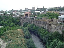
The river in Yerevan
|
|
| Country | Armenia |
| Basin | |
| Main source |
Lake Sevan 1,904 m (6,247 ft) |
| River mouth |
Aras River 826 m (2,710 ft) |
| Basin size | 2,560 km2 (990 sq mi) |
| Physical characteristics | |
| Length | 141 km (88 mi) |
| Discharge |
|
Hrazdan (Armenian: Հրազդան) is a major river and the second largest in Armenia. It originates at the northwest extremity of Lake Sevan and flows south through the Kotayk Province and Armenia's capital, Yerevan; the lake in turn is fed by several streams. In the Ararat plain it joins the Aras River along the border with Turkey. A series of hydro-electric plants have been constructed on the river. Its waters are in demand to irrigate crops. It also meets drinking water requirements and provides for recreation.
The river was called Ildaruni in Urartian. It was later known by the Turkic name Zangu (Armenian: Զանգու),Zanga,Zangi, or Zengy.
The Sevan Lake (with 30 rivers contributing to its storage, the largest located in the central part of the country and the Hrazdan River which originates from it, together form the "Sevan-Hrazdan Management Area", which is one of the five sub-basins of the 14 sub-basins of Kura and Araks basins of Armenia. The river originates from the lake at an elevation of 1,900 metres (6,200 ft). The river which flows from the lake in a southern direction passes through a deep gorge as it enters on the western side of the Yerevan city, and then debauchees into the Aras River on the southern side of the city. The geological formations along the river course are made up of lava flows (existing as basalts) generated from three volcanoes in the Gegham range. The lava surfaces represent environments that existed in the form of "lakes, river channels and floodplains". The chronology of landscape of the upper most layer of basalts indicates an age of 200,000 years.
The river drains a total catchment area of 2,566 square kilometres (991 sq mi). Precipitation volume is 1572 million cubic metre from an annual rainfall of 257 millimetres (10.1 in) with a maximum of 43 millimetres (1.7 in) in May and a minimum of 8 millimetres (0.31 in) during August. The average temperature recorded in the basin varies from −3 °C (27 °F)in January to 26 °C (79 °F) in July with diurnal variation with the lowest night temperature of −15 °C (5 °F) in January and highest day temperature of 44 °C (111 °F) in July. The total flow in the river is 733 million cubic meter. The regulated outflow into the river, which forms the Ararat Valley, is utilized for irrigation and hydro-power benefits. There are many cities and villages located along the river bank like the Sevan, Hrazdan, Charentsavan, Bjni, Arzni, Yerevan, and Masis with a total population of about 1,130,000.
...
Wikipedia
